7.5 Interwar Years: The Atlantic Colonies

Painted in 1835, this work by Robert Petley shows African-American refugees -- nominally "Black Loyalists" -- near Bedford Basin. (Courtesy, Library and Archives Canada, C-115424.)

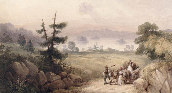
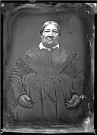
Figure 7.10 Painted in 1835, this work by Robert Petley shows African-American refugees — nominally “Black Loyalists” — near Bedford Basin.

Greater Nova Scotia

The population of Nova Scotia changed radically at the end of the Revolution. In 1764 there were about 13,000 people in the whole colony, which included what would become New Brunswick and Cape Breton. Halifax was easily the largest town but with only 3,000 people. Up to 30,000 Loyalists arrived from the old British colonies and the pattern of settlement changed overnight.[footnote]Statistics Canada, Censuses of Canada, 1665-1871. http://www.statcan.gc.ca/pub/98-187-x/4064810-eng.htm#part3[/footnote]

The Saint John River Valley became a particular focus of growth, as did port communities like Shelburne and the Afro-Nova Scotian community of Birchtown — the largest free Black community in North America. Saint John emerged as a modest-sized town and was the first incorporated city in what is now Canada. It was also a highly exclusive centre, with civic laws prohibiting the settling of African-New Brunswickers and barring from the trades and other occupations Whites who were neither Loyalists nor descended from Loyalists. Indeed, Loyalism was more of a fetish in Saint John than in many other settlements. The town attracted many of the most socially distinguished refugees, including the family of General Benedict Arnold (1741-1801), the Continental Army commander who switched to the British side in the course of the war.

The Saint John settlers petitioned London for a separate colony of their own, partly because they felt distant from and ignored by Halifax, but also because they regarded Haligonians as suspiciously democratic in their politics. Thus, in 1784, Nova Scotia was partitioned into two colonies along the Fundy-Chignecto axis.  A new capital for New Brunswick was established at Fredericton, nearly 100 kilometres up the Saint John River. This position was more easily defended than Saint John, should the Americans choose to attack some day, but it divided New Brunswick society into an administrative capital and a commercial capital. Acadians returned in growing numbers but they gave the Saint John region a wide berth, preferring to settle instead on the northeast coast of the renamed colony.

The years after 1783 proved particularly disappointing for the part of the Wabanaki Confederacy living in New Brunswick. During the Revolution they had shelved their hostility toward the British and provided support against the American rebels and expansionists from Maine. After the war and the Treaty of Paris, the Mi’kmaq and Malicite were neglected by authorities in both Saint John and Halifax. The Proclamation Act of 1763, which obliged Parliament to address Aboriginal land title, was held to apply only to the Ohio Valley and not to the Wabanaki homeland. The new regimes in Fredericton and Halifax were no less anti-Catholic than was the case before 1775, perhaps more so. This didn’t help the Mi’kmaq, whose people had been converting to Catholicism since 1610. Marginalized in the post-Revolutionary War years, the Mi’kmaq made common cause with other groups who found themselves out of the mainstream: African Loyalists, Irish immigrants, and Acadian returnees. Intermarriage between the groups was common, especially on the south shore of Nova Scotia.

Similar practices occurred in Cape Breton, also carved off from Nova Scotia in 1784. Returning Acadians were generally pushed along through Nova Scotia and on to the island where they settled in communities alongside Irish immigrants. Scots began arriving about the same time. Cape Breton’s future as a community of Gaelic-speaking, coal-mining fiddle players was, however, still some decades away.

The economy of Cape Breton — and that of the rest of the Maritimes — enjoyed a brief surge in the post-revolutionary years. The British Navigation Acts prohibited the transport of British goods on ships that were not British-made. This meant that products of British colonies as well as in the home country could only be carried in ships built either in Britain or her colonies. When the British made it clear that the Acts were going to be applied to post-revolutionary New England (the source of much of Britain’s colonial shipping capacity, lumber, and surplus fish sales), the Maritimes stepped — or fell — into the breach. Shipbuilding, mast-making, and the fisheries expanded to take advantage of the exclusive markets in the West Indies. Sadly, the region simply could not achieve the level of surpluses needed to serve and control the market. Food production in the colonies was limited and little was left over for export. Although shipping surged forward, it could not hope to fill the gap left by New England.

Exercise: Documents

Loyalist Women in Exile

In 1787 Polly Dibblee wrote to her brother, William Jarvis, complaining of the plight of Loyalist exiles in New Brunswick.

Kingston, New Brunswick
[17 November 1787]

Dear Billy

I have received your two Letters and the Trunk, and I feel the good Effects of the Clothes you sent me and my Children, and I value them to be worth more than I should have valued a thousand Pounds sterling in the year 1774. Alas, my Brother, that Providence should permit so many Evils to fall on me and my Fatherless Children — I know the sensibility of your Heart — therefore will not exaggerate in my story, lest I should contribute towards your Infelicity on my account— Since I wrote you, I have been twice burnt out, and left destitute of Food and Raiment; and in this dreary Country I know not where to find Relief — for Poverty has expelled Friendship and charity from the human Heart, and planted in its stead the Law of self-preservation – which scarcely can preserve alive the rustic Hero in this frozen Climate and barren Wilderness—

You say “that you have received accounts of the great sufferings of the Loyalists for want of Provisions, and I hope that you and your Children have not had the fate to live on Potatoes alone”— I assure you, my dear Billy, that many have been the Days since my arrival in this inhospitable Country, that I should have thought myself and Family truly happy could we have “had Potatoes alone” –but this mighty Boon was denied us!– I could have borne these Burdens of Loyalty with Fortitude had not my poor Children in doleful accents cried, Mama, why don’t you help me and give me Bread?

O gracious God, that I should live to see such times under the Protection of a British Government for whose sake we have Done and suffered every thing but that of Dying—

May you never Experience such heart piercing troubles as I have and still labour under — You may Depend on it that the Sufferings of the poor Loyalists are beyond all possible Description— The old Egyptians who required Brick without giving straw were more Merciful than to turn the Israelites into a thick Wood to gain Subsistence from an uncultivated Wilderness— Nay, the British Government allowed to the first Inhabitants of Halifax, Provisions for seven years, and have denied them to the Loyalists after two years– which proves to me that the British Rulers value Loyal Subjects less than the Refuse of the Gaols of England and America in former Days— Inhumane Treatment I suffered under the Power of American Mobs and Rebels for that Loyalty, which is now thought handsomely compensated for, by neglect and starvation— I dare not let my Friends at Stamford know of my Calamitous Situation lest it should bring down the grey Hairs of my Mother to the Grave; and besides they could not relieve me without distressing themselves should I apply– as they have been ruined by the Rebels during the War— therefore I have no other Ground to hope, but , on your Goodness and Bounty—

I wish every possible happiness may attend you, and your amiable Wife, and Child–and my Children have sense enough to know they have an Uncle Billy, and beg he will always remember them as they deserve.

I have only to add– that by your Brother Dibblee’s Death– my Miseries were rendered Compleat in this World but as God is just and Merciful my prospects in a future World are substantial and pleasing— I will therefore endeavour to live on hopes till I hear again from you— I remain in possession of a graceful Heart,

Dear Billy,
Your affectionate Sister,
Polly Dibblee[footnote]Letter from Polly Dibblee to William Jarvis, 17 November 1787, Kingston, “Loyalist Women in New Brunswick, 1783-1827,” Atlantic Canada Virtual Archives, diplomatic rendition, document no. 13_41. Audit Office, series 13, bundle 41, is available at National Archives, London. [/footnote]

Correspondences are a way of showing what one, as the author, thinks but they are also a means of changing the mind of the reader to whom the letter is sent.

What does Polly Dibblee want from her brother? How does she hope that he will understand her situation and that of the Loyalists generally? What message does she wish to convey?

Note that some words are capitalized mid-sentence — is there a pattern?

Prince Edward Island

Prince Edward Island’s situation was unusual in the region. Acadians from all over Nova Scotia fled to the island beginning on 1755, one step ahead of the Expulsion and war. They brought the size of the Acadian population to more than 5,000. Their conditions were difficult: housing was inadequate, food was in short supply following three bad seasons in a row, and everyone was nervous at the prospect of further deportations. They didn’t have long to wait. In 1758 — in the midst of the Seven Years’ War — a local expulsion began. Nearly 1,000 deportees died in shipwrecks on the way to France in late 1758.

In 1767 the whole of St. John’s Island, as it was then known, was divided into 67 lots of roughly 20,000 acres apiece. These were distributed in a lottery in London to aristocratic and other well-to-do investors whose responsibility it was to settle the land with farmers. Rather than wait on a natural flow of immigrants, this experiment proposed to draft settlers into a quasi-feudal tenant-farmer agricultural colony. The project failed badly. Settlers were slow in coming and the absentee landlords (or proprietors) sometimes abandoned entirely their obligations to the colony. From late in the 18th century until the 1870s, the Islanders would petition and demand of Britain that the unsettled and unserviced land be put up for freehold sale. Islanders were convinced that this system was a drag on their economic growth and a constraint on investment in the colony.

Efforts to seize defaulting proprietors’ lands led to the recall of Governor Walter Patterson in 1786. It was out of this failed attempt to repossess the land — a process called escheat  — that Islanders initiated an indigenous political movement and the Escheat Party, which was clearly in opposition to the interests of the larger landowners and their British sponsors. In 1798, in order to avoid confusion with St. John’s, Newfoundland, and Saint John, New Brunswick, the British government changed the colony’s name to Prince Edward Island. The colony developed strong links with British markets and was an early tourist resort for wealthy travellers from late 18th century England and for ships sailing out of New England.

Prince Edward Island in 1775, showing the proprietors' land parcels.

Figure 7.11 Prince Edward Island in 1775, showing the proprietors’ land parcels.

Newfoundland

The War of Independence was a pivotal time for Newfoundland. The fisheries economy of the colony was always exposed during wartime because of the demand created for naval sailors, many of whom were plucked from Newfoundland’s cod industry. As well, Newfoundland shipping was increasingly vulnerable to American privateers who could, by seizing Newfoundland craft, hurt the British economy, reduce the size of the Newfoundland fleet, deny the Royal Navy some sailors, and head for home with a valuable supply of cod. The loss of food supplies from New England in the early years of the war was an even more significant trauma for the island colony, one that provoked famine conditions for two years.[footnote]”Exploration and Settlement,” Newfoundland and Labrador Heritage. http://www.heritage.nf.ca/exploration/amer_rev.html. [/footnote]

The population of Newfoundland was made up mostly of transient fishermen, people who worked with the fleets from Europe without sinking roots into the outport communities and the resident community. The transients left in large numbers as wartime conditions worsened. For the first time, Newfoundlanders were mostly residents.

Increasingly, the residents became merchants. The business model of the transient or migratory fishery had been irrevocably damaged by the war and Britain could no longer run the colony as a fishery station. Now there was room for residents to engage more fully with the fisheries and with import/export economies, as was made clear with two developments.

First, St. John’s emerged as a hub of commercial and administrative activity. At the end of the Revolution there were barely a thousand people in St. John’s; less than 30 years later there were more than 10,000. Second, the population of the colony as a whole expanded dramatically, rising to 20,000 in 1800. Fed mostly by Irish immigration (both Catholic and Protestant), the population continued to grow into the mid-19th century.

James Cook's map of Newfoundland, published 1775. Three years after this appeared Cook would be charting the Pacific coastline.

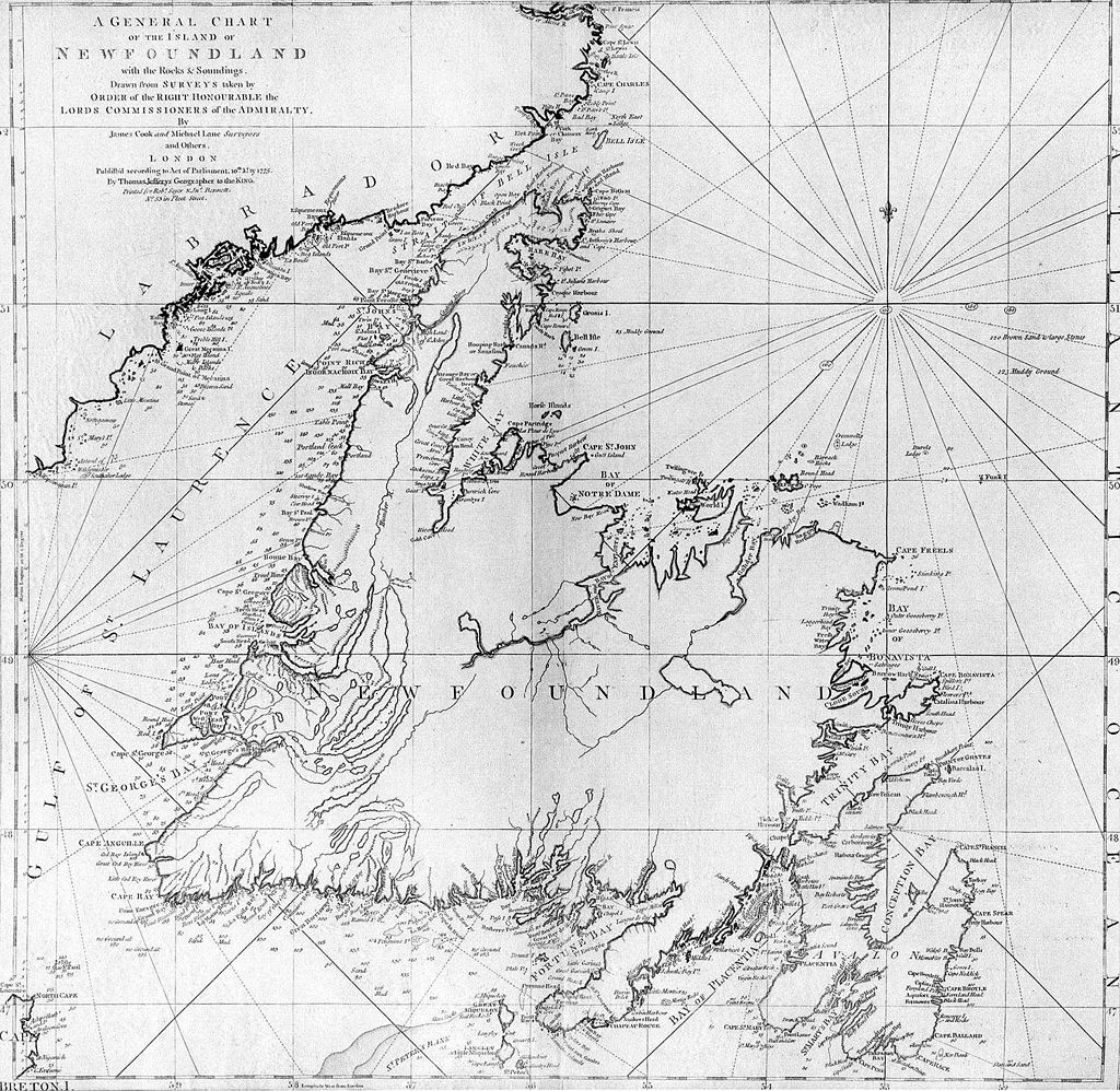
Figure 7.12 James Cook’s map of Newfoundland, published 1775. Three years later Cook was charting the Pacific coastline of North America.

Tension existed within this community because Newfoundland lacked a formal, elective type of government; in its place it had a small elite of St. John’s merchants (mostly Protestant) and an officers’ corps, both of which advised the governor. This arrangement alienated some of the Irish and others in the community, and led to a failed coup in 1800, which ended with the execution of eight members of the conspiracy.

More subtly, the demographics of Newfoundland did much to shape the community that evolved. At the start of the century one legacy of the transient fisheries was still evident: the distorted ratio of men to women. Because Britain did not (officially) want to stimulate settlement and colonial population growth, it had discouraged female immigration. As residency grew, this constraint was lifted and the number of women in Newfoundland increased, resulting in an intensification of permanent settlement in individual outports.

Regular traffic between Newfoundland and Ireland enabled men to find brides at home and bring them to the colony. It also produced generations of children, something that had not been witnessed in the Euro-Newfoundlander population in any significant numbers before 1800. For the first time, education became the focus of attention. As Willeen Keough has shown, the arrival of Irish women on the southern Avalon created a cadre of females who were part- or full-owners of fishing businesses (called “plantations”), employers of fisheries “servants,” active in the shore crews, owner/operators of small businesses, farmers, and key to the emergence of a household economy consisting of more than one generation.[footnote]Willeen Keough, “The Riddle of Peggy Mountain: Regulation of Irish Women’s Sexualtiy on the Southern Avalon,” Acadiensis 31, no. 2 (Spring 2002): 38-70.[/footnote]

These changes in Newfoundland society had a visible impact on the landscape. Forests along the foreshore were cut down and used for lumber and fuel. Even before the great boom in Newfoundland’s forest industry in the 19th century, more and more rock was emerging from underneath the stumps of former tree stands. Whaling, which had been a pastime of the Basque fleet for centuries, had severely reduced cetacean numbers and may have stimulated the health of the cod population as they were no longer prey or competitors of the large sea mammals. The capture of foreshore positions for fishing stations and deforestation had another impact: it reduced Aboriginal access to traditional resources.

The Beothuk, an Algonkian-speaking group about whom little is known, engaged in trade and scavenging but increasingly avoided direct contact with Europeans as the fleet-sizes increased.[footnote] William Gilbert, “Beothuk-European Contact in the 16th Century: A Re-evaluation of the Documentary Evidence,” Acadiensis XXXX, no. 1 (Winter/Spring 2011): 24-44.[/footnote] They retreated inland when the European fishing crews were on shore, and then raided their abandoned sites for metal nails from which they could fashion their own tools. There was armed conflict between the Beothuk and the Europeans, and also against the Mi’kmaq who had settlements along the south coast of Newfoundland. The Beothuk depended heavily on the migratory caribou herd, which was impacted by European settlement on the Avalon Peninsula, and on the spawning routes of the salmon fishery, which was disrupted by Euro-Newfoundlanders’ logging along the island’s river systems.[footnote]Ralph T. Pastore, “The Collapse of the Beothuk World,” Acadiensis XIX, no. 1 (Fall 1989): 59-64.[/footnote]

A miniature portrait of Demasduit by  Lady Henrietta Hamilton, ca.1819.

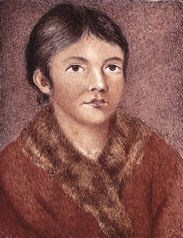
Figure 7.13 A miniature portrait of Demasduit by Lady Henrietta Hamilton, ca.1819.

Exotic diseases cut a swathe through their population, especially tuberculosis. By the start of the 19th century, the resource base of the Beothuk was badly depleted and they were facing famine. In 1819 and 1823, two women from a shrinking Beothuk population established the longest known relationships with Europeans. The first, Demasduit, was captured in a brutal assault that claimed the life of her husband and doomed her infant child. She nevertheless lived in St. John’s for nearly a year before perishing from tuberculosis. Shanawdithit and two members of her family were on the brink of starvation when they threw themselves on the mercy of the European community. Her relations died soon after — again, from tuberculosis — and Shanawdithit succumbed herself after six years among the Europeans. Much of what is known about the Beothuk derives from these two brief encounters. By 1829, or possibly not long after, the Beothuk were extinct.

The Beothuk were among the first Aboriginal people to encounter Europeans. Their disappearance in the early 19th century had a number of impacts on colonial understanding of indigenous peoples. The Beothuk were characterized for generations as a primitive people, a Paleo-Indian branch that was backward by Aboriginal standards and thus doomed to disappear. Explaining their extinction implicitly involved exculpation of European guilt: if they were doomed, they were doomed and nothing that Europeans did to slow or hasten that outcome would matter. What’s more, the Beothuk — the original “red indians” — as a “fated” people were invoked as foreshadowing of what awaited Aboriginal people across North America.[footnote]Donald H. Holly Jr. and Paul Sant Cassia, “A Historiography of an Ahistoricity: On the Beothuk Indians,” History & Anthropology 14, issue 2 (June 2003): 127-40.[/footnote]

Key Points

  • The Loyalist migration transformed and complicated the population and political geography of Nova Scotia and Quebec, producing new colonial configurations and social problems.
  • The colonial landscape of Prince Edward Island was swept clean and was marked by a unique absentee landowner class.
  • Newfoundland’s settler society was spurred on by the commercial possibilities created by the Revolution and it started to grow in earnest.
  • The fate of the Beothuk points to the ecological incompatibility of the newcomer and Aboriginal societies on Newfoundland.

Attributions

Figure 7.10
Bedford Basin near Halifax by Robert Petley is in the public domain. This image is available from the Library and Archives Canada, acc. no. 1938-220-1.

Figure 7.11
Prince Edward Island map 1775 by SriMesh is in the public domain.

Figure 7.12
Cooks Karte von Neufundland by Schaengel89 is in the public domain.

Figure 7.13
Demasduit by Nikater is in the public domain.

Posted in Uncategorized | Leave a comment

Chapter 14. The 1860s: Confederation and Its Discontents

Posted in Uncategorized | Comments Off on Chapter 14. The 1860s: Confederation and Its Discontents

13.11 Summary

A staged photograph from a Kwakwaka'wakw potlatch in the early 20th century shows the survival and resilience of northwest coast cultural practices. (Photo by Edward Curtis.)

Figure 13.35 A staged photograph from a Kwakwaka’wakw potlatch in the early 20th century shows the survival and resilience of northwest coast cultural practices. (Photo by Edward S. Curtis, ca. 1915.)

The territory that became British Columbia joined the Canadian federation in 1871. Until that time, however, Canada was very distant and rather foreign and mostly irrelevant. The orientations of the Pacific Northwest were toward Asia, the Pacific Islands, Mexico and Chile, and round Cape Horn to England. For the many Aboriginal peoples and cultures in the region, Canada was a country with which they had effectively no contact and hardly more knowledge. The challenge, then, is to understand these pre-Confederation years as an era in which other priorities and possibilities presented themselves.

The colonies of British Columbia and Vancouver Island were expensive to maintain, especially as the gold rush ended and the population diminished. From a peak of 10,000 the Cariboo population fell to about 1,000 by 1870. It is estimated that there were only about 2,000 Chinese left in the colony. The Cariboo Wagon Road had cost the mainland colony dearly and pitched it into debt. The capital at New Westminster — dominated by merchant houses, a colonial elite, and a Royal Engineers’ community ensconced at Sapperton — was desperate to hold onto its administrative role.

In 1866 the mainland and the island colonies were consolidated. Bits and pieces of New Caledonia, the Stikeen Territory, the Colony of the Queen Charlotte Islands, and the post-Rupert’s Land North-Western Territory had been gradually grafted onto British Columbia and this was the final piece. And — much like Lower Canada in 1841 — Vancouver Island inherited British Columbia’s debt.

Newspaperman John Robson imported the vocabulary of Upper Canadian reform politics to New Westminster.

Figure13.36 Newspaperman John Robson imported the vocabulary of Upper Canadian reform politics to New Westminster.

The political culture that developed west of the Rockies was, like the population, multifaceted. There were powerful British themes promoted by the Colonial Office alongside Canadian traditions brought west by Upper Canadians like the reformer John Robson. There was a democratic tradition that can be ascribed, in part, to the Americans and Nova Scotians, such as Amor de Cosmos, a harsh critic of the squirearchy in Victoria. The HBC’s tradition of hierarchy and discipline was increasingly caricatured as a West Coast variant of the Family Compact. It was in some respects — in terms of the close bonds between the chief administrator and the members of the Victoria elite — even more of a family compact than ever existed in Upper Canada. Well-positioned individuals like Joseph Trutch were vitriolic in their opposition to democratic reforms. The four years after Confederation in the East would see the colonists in British Columbia pulled in different directions.

While that debate was underway, Aboriginal communities continued to stagger from hardship to hardship. As early as 1852 Douglas had witnessed privation and perhaps starvation among the Lekwungen with whom he had signed an early treaty. They were no longer at the centre of the local economy, a change that had taken place in a matter of 10 years.

It is possible to argue that the fur trade on the West Coast was a period of mutual benefit. This is the position taken by Robin Fisher in his landmark book Contact and Conflict, in 1977.[footnote]Robin Fisher, Contact and Conflict: Indian-European Relations, 1774-1890, 2nd ed. (Vancouver: UBC Press, 1992).[/footnote] He argues that both sides profited from the trade and whatever cultural change occurred in Aboriginal societies was mediated and controlled by Aboriginal peoples themselves. The absence of missionaries and/or imperial power until the 1840s is at the heart of this argument. Other historians have taken the position that the epidemic waves beginning in the 1780s, if not earlier, meant that the odds were stacked against Aboriginal ability to adapt. Still others point to the extent of Aboriginal authority in the fur trade, the extent to which indigenous people were able to exploit newcomer dependence, and the ways in which Aboriginal peoples managed newcomer behaviours as a sign of ongoing autonomy.

The gold rush of 1858 and the smallpox epidemic of 1862 rendered much of this moot. A territory over which Britain and Spain were once prepared to go to war had so fallen off the European radar that the events of 1858-63 threw it all up in the air again. As Douglas and his colleagues in the HBC retired from public life and passed away, links with the pre-gold rush past evaporated. For the British Columbians of 1858-1871 there was not much in the way of a history to their colony, and what history they saw they generally didn’t like. The future was the thing, and they would sacrifice much to get there.

Key Terms

Cariboo Wagon Road: A road constructed from 1860 to 1885 to connect the Lower Mainland of British Columbia with the Cariboo goldfields. The original 1860-63 road ran from Port Douglas at the north end of Harrison Lake via Lillooet to Clinton and then north across the Cariboo Plateau to Alexandria. An amended version in 1865 connected Yale to Ashcroft and then Clinton and the older road, having passed through the Fraser Canyon.

Chilcotin War: Also referred to as the Chilcotin Massacre, Chilcotin Uprising, and Bute Inlet Massacre. Occurred in 1864 when Tsilqot’in people asserted their control of their ancestral territory by murdering several members of a road-building crew and some colonists. The colonial authorities responded with a fruitless and expensive campaign that only ended when several of the Tsilqot’in leaders presented themselves for negotiations and were summarily arrested and subsequently hanged.

Church Missionary Society (CMS): Established in London, England, in 1799. Began sending Anglican missionaries to Rupert’s Land in the 1820s. In 1857 William Duncan was dispatched to the northwest coast on behalf of the CMS.

Douglas treaties: Also known as the Fort Victoria Treaties, 14 agreements between the Colony of Vancouver Island (under the leadership of James Douglas) and Aboriginal communities. These were one-time land purchase treaties that protected Aboriginal village sites and fields, as well as access to resources.

Fifty-Four Forty or Fight!: Slogan coined in 1844 or 1845 by American expansionists eager to claim the whole of the Oregon Territory to the Alaska panhandle (54°40’N).

Fort George: The name of two forts in the Pacific northwest. The first replaced the American Fort Astoria near the mouth of the Columbia River (at what is now Astoria, Oregon), and the  second was established in 1807 by Simon Fraser at the site of what is now the city of Prince George, British Columbia.

Fort Rupert: Located at the north end of Vancouver Island near modern-day Port Hardy. Established by the HBC as a coal harvesting/mining experiment. It is an important Kwagu’ł community today and should not be confused with the city of Prince Rupert, much farther north on the mainland, nor with Waskaganish in northern Quebec, which was formerly called Fort Rupert.

Fort Vancouver: An HBC fort established in 1824-25 about 60 kilometres up the Columbia River from Fort George (formerly Fort Astoria). Now the site of the city of Vancouver, Washington. The city of Vancouver, British Columbia, was never a fort and there is no relation between the two other than the name.

Fraser River gold rush: A mining boom beginning in 1858 characterized by large numbers of independent prospectors using simple mining technologies to extract gold flakes, dust, and nuggets from the Fraser River. This gold rush was superseded by better finds in the Cariboo in the 1860s.

gold fever: Term used to describe the opportunistic individualism found in gold rushes. Gold was discovered and mined by independent prospectors around the Pacific Rim beginning in Australia from the 1840s, California from 1848, a brief flurry in Haida Gwaii in the 1850s followed by the British Columbia rush from 1858-63, and New Zealand in the 1860s. After Confederation there were smaller rushes in British Columiba  and these were surpassed by the Klondike/Alaska gold rush of 1896-1909. The close succession of gold rushes meant that many of the personnel in the goldfields had experience in other gold rushes and many of the gold field institutions followed in their wake.

gunboat diplomacy: The achievement of colonial political goals in dealings with Aboriginal communities by means of superior naval firepower.

land-based fur trade: Refers to the HBC’s strategy in the 1830s to establish permanent fur-trading establishments on land, rather than rely on ships cruising the coast looking for trade. (See maritime-based fur trade.)

Manifest Destiny: Widespread belief in the United States during the 19th century that America was destined — that is, intended by God — to conquer and occupy most if not all of North America.

maritime-based fur trade: The European and American practice dating from the 1770s of trading up and down the coast from ships, rather than establishing fixed positions on land.

Nootka Crisis: A diplomatic incident due to conflicting between Spanish and British claims to sovereignty and the right to trade along the Pacific northwest coast. The disagreement was resolved in the Nootka Conventions of 1790-1794. Despite the negotiations taking place at Yuquot, Mowachat interests and claims to sovereignty were disregarded.

Oregon Treaty, 1846: Settled the boundary between the United States and the British territories west of the Rockies at 49°N.

potlatch: An Aboriginal ceremonial event common across the Pacific Northwest. Involves the giving of gifts by the host to mark a life event like an inheritance or succession.

Puget Sound Agricultural Company (PSAC): Established in 1838-39 by the HBC to provide food for its posts and surpluses for sale to the Russian American Company.

Russian American Company (RAC): Chartered in 1799, the RAC was principally focused on the sea otter fur trade and also established outposts in Alta California and Hawaii.

sea otter pelts: On the West Coast the principal fur traded by Aboriginal communities to European and American buyers for sale in the Chinese marketplace.

Short Answer Exercises

  1. How did Aboriginal peoples on the northwest coast and on the mainland respond to contact with Europeans from the 1740s to the 1840s?
  2. What impacts did the sea otter trade have on northwest coast cultures?
  3. How did Britain emerge as the leading imperialist presence on the West Coast north of the Columbia River and south of Alaska?
  4. In what ways was the fur trade west of the Rockies different from what occurred to the east?
  5. How was the maritime fur trade on the northwest coast different from the land-based trade (both on the coast and in the Interior)?
  6. What were some of the demographic impacts of contact on the northwest coast from the 1780s to the 1860s?
  7. Why did the HBC move its operations to Fort Victoria and what were the expectations of both London and the local indigenous communities?
  8. In what ways did the HBC diversify its activities on the northwest coast after the 1830s?
  9. Why was there a coal industry on Vancouver Island in the 1850s and 1860s?
  10. How did Aboriginal societies resist colonialism?
  11. How did the gold rush impact colonial development?
  12. What was the demographic character of the gold rush?
  13. What was the character of local colonial government from the 1840s to 1870?
  14. How did Native-newcomer relations change from the 1830s to the 1860s?

Suggested Readings

  1. Barman, Jean. “Taming Aboriginal Sexuality: Gender, Power, and Race, 1850-1900.” BC Studies,115/116 (Autumn/Winter 1997): Audio. http://bcstudies.com/?q=full-site-search&search_api_views_fulltext=Taming+Aboriginal+Sexuality%3A+Gender%2C+Power%2C+and+Race+in+British+Columbia
  2. Belshaw, John Douglas. “The West We Have Lost: First Nations Depopulation.” In Becoming British Columbia: A Population History, 72-90. Vancouver: UBC Press, 2010.
  3. Harris, Cole. “The Native Land Policies of Governor James Douglas.” BC Studies 174 (Summer 2012): 101-122.
  4. Perry, Adele. “Hardy Backwoodsmen, Wholesome Women, and Steady Families: Immigration and the Construction of a White Society in Colonial British Columbia, 1849–1871.” Histoire Sociale/Social History 33, no.66 (November 2000): 343-360.
  5. Wickwire, Wendy C. “To See Ourselves as the Other’s Other: Nlaka’pamux Contact Narratives.” Canadian Historical Review LXXV, no.1 (March 1994): 1-20.

Attributions

Figure 13.35
Showing of masks at Kwakwaka’wakw potlatch by User:Deadstar is in the public domain.

Figure 13.36
Portrait de John Robson by Digging.holes is in the public domain.

Posted in Uncategorized | Leave a comment

13.8 The Island Colony

The south-west bastion of the HBC fort at Victoria, 1860. (Watercolour by Sarah Crease.)

Figure 13.24 The southwest bastion of the HBC fort at Victoria, 1860. (Watercolour by Sarah Crease.)

The loss of the Oregon Territory was a blow to the HBC but not necessarily to British ambitions in the region. The former remained resilient while the latter remained modest. The HBC had experimented with commercial diversification for years, expanding its network across the Pacific. The arrival and employment of Kanakas throughout the Pacific Northwest reflected the diversity of marketplaces into which the HBC reached.[footnote]Tom Koppel, Kanaka: The Untold Story of Hawaiian Pioneers in British Columbia and the Pacific Northwest (Vancouver: Whitecap Books, 1995).[/footnote] It was clearly about much more than beaver and sea otter pelts.

One noteworthy (if Pyrrhic) victory in this regard was the Puget Sound Agricultural Company (PSAC), a barely-at-arm’s-length subsidiary of the HBC created in 1840 and centred at Port Nisqually (Tacoma) in what is now Washington State. The PSAC had several goals, including the establishment of a loyal British settler community in the face of American intrusion into the Oregon Territory, improved self-sufficiency in terms of food supply to the northern forts, and an experiment in settler colonialism. Like Lord Selkirk’s project at Red River, the HBC conceived PSAC in part as an attractive retreat for retired employees and their families. The Oregon Treaty ended the PSAC experiment but its objectives were to continue to the north, on Vancouver Island.

Fort Victoria

Fort Camosun opened in 1843 and its name changed to Fort Victoria in 1846 in honour of the new queen. This was the first settlement of Europeans on the island since the Spanish abandoned Fort San Miguel at Yuquot in 1795. The HBC feared the Lekwungen (Songhees) and their neighbours, and there was little confidence that even a simple landfall would succeed. The priorities of the Lekwungen, however, included incorporating the British operations into their own. Some 300 to 400 Aboriginal men took on the task of building the fort and the band provided all the lumber required for the task. Historian John Lutz argues that this apparent welcome was a kind of appropriation by the Lekwungen. In their society, housebuilding was a communal activity and it was one that signified, importantly, community ownership of the structure. Building the HBC fort, therefore, signified a Lekwungen stake in the affair.[footnote]John Lutz, Makuk: A New History of Aboriginal-White Relations (Vancouver: UBC Press, 2008), 70-71.[/footnote]

Relations between Aboriginal peoples and the HBC entered a new phase after the construction of Fort Victoria. There were confrontations, some of which involved what Barry Gough describes as gunboat diplomacy.[footnote]Barry M. Gough, Gunboat Frontier: British Maritime Authority and Northwest Coast Indians, 1856-1890 (Vancouver; UBC Press, 1984).[/footnote] Often the source of irritation was cultural differences. Many northwest coast peoples were horticulturists, though not farmers in a sense that newcomers instantly recognized. Europeans often witnessed them clearing the land with fire in order to create meadows, so the newcomers knew that land management was underway. For example, the West Coast camas bulb was an important source of food for Aboriginal peoples and a trade good in its own right. But the camas bulb is one of many indigenous foodstuffs that did not gain admittance to the Columbian Exchange: Europeans never really came to like its flavour. If they had, they might have done more to protect camas patches against the newly introduced cattle and pigs. Of course, a cleared patch of land is more attractive to a farming settler than a stand of towering Douglas firs: the gardens of northwest coast peoples were much sought after and were quickly seized by newcomers. Aboriginal peoples, for their part, regarded anything on four legs as potential game, which was predictably bad news for livestock and for the newcomer-Native relationship, but good news for the banquet table.

The gundeck of the steam-powered vessel, the HMS Sutlej. Along with the aptly named Devastation, the Sutlej played a part in the razing of nine native villages in one mission during the 1860s. (National Archives of Canada)

Figure 13.25 The gundeck of the steam-powered vessel, the HMS Sutlej. Along with the aptly named Devastation, the Sutlej razed nine native villages in one mission during the 1860s.

The Colony of Vancouver Island

In 1849 the British extended to the HBC a 10-year lease on the proprietary colony of Vancouver Island, conditional on its settlement by newcomers. The new colonial paradigm was difficult for the HBC to accept. Settlers and furs and Natives were not viewed as a good mix, not by the HBC’s officers and not by the Aboriginal populations. The Whitman Massacre of 1847 was still at the forefront of everyone’s minds. Aware of the possibility of foot-dragging on the settlement front, the Colonial Office dispatched Richard Blanshard (1817-1894) to serve as governor.

Blanshard was probably the only non-indigenous person on the whole island who did not work for the HBC and, as he was soon to discover, the company did not work for him. In the space of 10 years the HBC had experienced an enormous shift, one that had seen the end of their Oregon and Californian enterprises along with the loss of Fort Vancouver and the York Factory Express route. The company’s local operations were headed by Chief Factor James Douglas but he now had to take orders from London and the Colonial Office. What’s more, Westminster instructed the HBC to bring in significant numbers of non-company personnel to become settlers; it was likely that the newcomers’ relationship with the Aboriginals would be different from — which is to say, at odds with — that of the fur trading company. It is hardly any wonder, then, that Governor Blanshard found himself isolated and frustrated. If that weren’t enough, his timing was spectacularly bad.

Richard Blanshard served briefly as the first governor of Vancouver's Island.

Figure 13.26 Richard Blanshard served briefly as the first governor of Vancouver Island.

Gold fever had erupted in California in 1848. By 1849 eager prospectors were streaming into San Francisco, some of them from Fort Victoria. At around the same time, the HBC decided to pursue more aggressively a coal mining possibility at the northern tip of the island. The company established Fort Rupert in the late 1830s at Beaver Harbour, a Kwagu’ł (Kwakiutl) village site called ʦax̱is. This was the company’s only fort that existed for purposes other than trading furs or growing food. Kwagu’ł men and women dug out the coal or gathered it along the beach and traded it to the HBC, thus expanding their range of commerce. By 1848, however, the company was preparing to lurch into the industrial age by bringing out a party of experienced Scottish coal miners. The experiment was a disaster. It outraged the Kwagu’ł and they made common cause with the miners against the HBC. In 1850 the Scots were either chained up in the fort’s bastion or preparing to make a run for it.

As this drama unfolded, another came into view. Two British sailors who hoped to hitch a ride to San Francisco and the riches of the Californian El Dorado jumped ship in Victoria and then, mistakenly, onto a vessel headed north. Arriving in a troubled Fort Rupert, they fled into the forest where they were murdered by parties unknown. Blanshard’s response was to sail a gunboat into Beaver Harbour and shell the nearby Nahwitti village as he pursued the killers. Fed up with his low wages, poor living conditions, and lack of real authority, he returned to Fort Victoria and submitted his resignation — which London was happy to accept, given his rampage at Nahwitti.

A depiction of Kwagu’ł and Tsimshean people at Fort Rupert on the north end of Vancouver Island, 1851. (Painting by Admiral Edward Gennys Fanshawe.)

Figure 13.27 A depiction of Kwagu’ł and Ts’msyan people at Fort Rupert on the north end of Vancouver Island, 1851. (Painting by Admiral Edward Gennys Fanshawe.)

Douglas was now governor of the colony with orders to take material steps to settle the island with colonists loyal to the Crown. Recruitment efforts were modest, not least because the prospect of new settlers was viewed as inconsistent with diplomatic and commercial relations with the Aboriginal peoples. There was a veneer of theory applied to this hesitance. In the early 1850s the colonial theories of Edward Gibbon Wakefield (1769-1862) — one of members of Lord Durham’s expedition to the Canadas — gained wider support. Wakefield’s views resonated nicely with the HBC establishment on the island: he thought it was better to reproduce in colonies the kind of social relations found in Britain’s hierarchical culture than to open up the land to homesteading and an influx of commoners. As a result, land prices were set at a level that was seen as attractively exclusive. Only a certain class of settler would, in effect, be admitted. In the face of free land policies south of the border, the Wakefieldian approach on Vancouver Island failed.[footnote]Tina Loo, Making Law, Order and Authority in British Columbia, 1821-1871 (Toronto: University of Toronto Press, 1994), 38.[/footnote] The number of land sales was acceptable, but the number of settlers was never great. What’s more, those HBC servants who might have had it in mind to achieve some independence on the land were kept in their social class by this expense, thus preserving a pool of labourers. Finally, the hierarchical society that Wakefield (and James Douglas) had in mind for Vancouver Island led to the creation of the “squirearchy,” an HBC-connected elite that occupied all the key appointed positions in the colony, including the whole of the judiciary.

The Crown had been reluctant to hand authority to Douglas for fear that he was in a conflict of interest. Indeed he was. Douglas was mistrustful of settlers and defensive of Aboriginal rights as he saw them. He negotiated a suite of 14 agreements, known as the Douglas treaties. These were initiated under Blanshard’s watch and Douglas continued pulling treaties together through the decade. Each aimed at obtaining lands deemed suitable for settlement or HBC enterprise. The treaties preserved First Nations village sites intact and allowed for one-time compensation payments. Some First Nations actively sought treaties from the HBC but Douglas had a limited budget at his disposal and no interest in obtaining territory where there was no immediate likelihood of use by newcomers. These treaties stand as the only ones negotiated west of the Rockies until very recently.

West Coast Industrialization

The experiment in coal mining at Fort Rupert was a disappointment. The Kwagu’ł claimed ownership of the coal and obstructed the use of Scottish miners. The immigrant coal miners — who constitute the first group of foreigners delivered to the region for the purpose of settling or doing a particular job since Meares’s Chinese shipbuilders — objected to the way the work was organized, the conditions under which they were mining, and the whole culture of HBC fort life. The operation was wound down and a promising coal seam to the south was explored. Many of the miners subsequently wound up at Fort Nanaimo in the Sneneymuxw territory. Douglas signed a treaty with the Aboriginal community in 1854 and in that year a shipload of English miners from Staffordshire arrived, along with their families. In total, the HBC sponsored the immigration of 435 individuals for the coal mining projects until 1855, 85 of which were children. These immigrants and those who followed them were exceptional in the history of Canadian population: they were working-class people drawn from isolated communities in Britain and their voyage west by sea took them around the southern tip of South America, to Hawaii, and then to the island colony. There was effectively no going back. In a colony where the “squirearchy” looked down its nose at agricultural labour, the status of the miners and their families was lower still.

The success of the coal mining enterprise was slow in coming. It was helped along, indirectly, by the Russians. The island’s proximity to Russian waters pulled the colony briefly into the orbit of the Crimean War (1854). A joint British-French assault on the Russian Pacific port of Petropavlovsk ended in disaster and the injured troops were evacuated to Fort Victoria. These events advanced the case for a Royal Navy base and one was established next to Victoria Harbour at Esquimalt in 1865. Naval officers subsequently developed close links with the coal mining operations around Nanaimo. As more steam-powered naval vessels arrived in the Pacific, the coal resources became more important; as the coal mines grew in strategic significance so too did the value of having a naval base nearby to protect them.

Figure 13.28 Coal miners at the Nanaimo mine pithead, ca. 1870.

The gold rush on the mainland also helped the coal mines, as did the growing demand for household fuel in San Francisco and Victoria. In the early 1860s the HBC sold its interest in Nanaimo to a London-based company and the chartered company gave way to industrial capitalism. A former HBC employee, Robert Dunsmuir, found his own coal seam nearby in 1869 and began building an industrial empire and dynasty. Two years earlier the first Chinese mine workers arrived at Nanaimo, the beginning of a migration wave that would continue through the rest of the century. By the third quarter of the century Nanaimo and environs was one of the largest industrial nodes in British North America.

Christianizers

Missionary activity on the coast also began at the mid-century. William Duncan (1832-1918), a controversial and mercurial representative of the Church of England’s Church Missionary Society (CMS), arrived in 1857. He set up shop at Fort Simpson (also known as Lax Kw’alaams and Port Simpson, near current-day Prince Rupert) and subsequently relocated hundreds of Ts’msyan to a mission town of his creation: Metlakatla. “Duncan shaped a landscaped place,” at Metlakatla, according to one source, “with rows of identical, single-family dwellings. Each house had a small garden, glass windows, sash curtains, and was fitted with beds and clocks. The church and other public offices were Metlakatla’s largest and most imposing buildings.” The overall effect was that of a European community built around ideals of individualism, the nuclear family, and “slum clearance.”[footnote]Daniel Clayton, “Geographies of the Lower Skeena,” in Home Truths: Highlights from BC History, eds. Richard Mackie and Graeme Wynn (Madeira Park: Harbour, 2012), 114-115.[/footnote] Duncan aimed to change people by changing their environment first: notably his idea of appropriate housing, individualism, and patrilineal inheritance was a direct critique of local Aboriginal culture. Duncan took the view that good Christians came out of nuclear households with a strong patriarchal legal and belief system in place.[footnote]Clarence Bolt, Thomas Crosby and the Tsimshian: Small Shoes for Feet Too Large (Vancouver: UBC Press, 1992), 24.[/footnote] While cultural change among Aboriginal people on the northwest coast had been occurring throughout the fur trade period, the arrival of missionaries like Duncan and his successor at Fort Simpson, the Methodist Thomas Crosby (1840-1914), witnessed the first concerted efforts by newcomers to transform Aboriginal societies and beliefs on the West Coast.

St. Paul's the Anglican church at Metlakatla, n.d. (U.S. National Archives and Records Administration)

Figure 13.29 St. Paul’s the Anglican church at Metlakatla, n.d.

The 1850s were marked, then, by a rising colonial administrative presence, the beginnings of cultural assaults, some increase in newcomer settlement, and further decline in the fur economy counterbalanced somewhat by increased diversification of HBC activities. Where Fort Rupert failed as a mining operation, Fort Nanaimo succeeded and new arrivals from British coal fields continued the process of industrial resource extraction. The decade also witnessed diversification of Aboriginal economies, a greater number of Aboriginal peoples trading their labour for goods, and significant instances of resistance to newcomer transgressions. All of this change would be very suddenly eclipsed by events in 1858.

Key Points

  • The HBC established the Colony of Vancouver’s Island to replace Fort Vancouver and as a starting point for a joint HBC-Colonial Office settlement project.
  • The presence of newcomers in their midst both enriched and endangered Aboriginal peoples of the island and the central coast.
  • Agriculture, harvesting coal, and other economic activities were undertaken to further trade with the foreigners and also to increase their dependence.
  • Settlement in the colony took two forms: a patriarchal and pastoral echo of the relationship between British gentry and commoners, and an industrial, proletarian townscape.
  • The industrial revolution arrived on Vancouver Island in the late 1840s and spread in the 1850s to the mid- and south island.
  • Missionary efforts on the West Coast accelerated in the 1840s, richly funded in the first instance by the CMS.

Attributions

Figure 13.24
Fort Victoria watercolour by Bonas is in the public domain.

Figure 13.25
HMS Sutlej gun deck LAC by Rcbutcher is in the public domain.

Figure 13.26
Blanshard by Fishhead64 is in the public domain.

Figure 13.27
Edward Gennys Fanshawe, Indians at Fort Rupert, Vancouver’s Island, July 1851 (Canada) by KAVEBEAR is in the public domain.

Figure 13.28
Nanaimo Mine Explosion-1 by Drovosekk is used under a CC-BY-SA 3.0 license.

Figure 13.29
William Duncan’s church, Metlakahtla, B.C. is in the public domain. This image is available from the holdings of the National Archives and Records Administration, cataloged under the ARC Identifier (National Archives Identifier) 297830.

Posted in Uncategorized | Leave a comment

13.6 Boundary Disputes and Manifest Destiny

The Oregon or Columbia District included parts of modern-day British Columbia, Idaho and Montana as well as all of Washington and Oregon. This map shows, too, the respective claims of the British (42 degrees) and the Americans (5440').

Figure 13.18 The Oregon or Columbia District included parts of modern-day British Columbia, Idaho, and Montana as well as all of Washington and Oregon. This map shows, too, the respective claims of the British (42 degrees) and the Americans (5440′).

Beginning in the early 1840s, “Oregon Fever” gripped the United States. Oregon was touted as a land of pleasant climates and fertile soil. Several thousand American settlers began a westward migration over the Oregon Trail. By the mid-1840s, some 5,000 Americans had populated the southern half of the Columbia Department, thus strengthening the U.S. claim to Oregon, and in 1843 the Americans declared a provisional government. The HBC’s James Douglas wrote to his superiors that “An American population will never willingly submit to British domination.”[footnote]James Douglas to George Simpson (private correspondence), 23 October 1843, quoted in Daniel W. Clayton, Islands of Truth: The Imperial Fashioning of Vancouver Island (Vancouver: UBC Press, 2000), 219.[/footnote] Britain’s tenuous hold on the whole region was in danger of slipping away. Oregon Fever, moreover, fuelled the idea of Manifest Destiny in America, popularizing the  the notion that it was God’s will that the republic should control the whole of the continent.

Fifty-Four Forty

American territorial expansion became one of the paramount issues of the U.S. election of 1844. Democrat James K. Polk, a protege of the expansionist Andrew Jackson (president, 1829-37), won office in an election that revolved largely around the issues of the possible annexation of Texas and acquiring some or all of the HBC-administered Columbia Department, which the Americans referred to as the Oregon Territory. Polk won the election by a narrow majority, but the Democrats took both houses of Congress, causing many to read the result as a mandate for expansionism.

Many Americans, Polk among them, set their sights on taking the Mexican provinces of New Mexico and California in addition to the Oregon Territory, which at that stage constituted most of the territory between California and the Alaska panhandle — that is, almost all of what is now British Columbia. Polk’s priority, however, was the Mexican territories and so he needed to quickly settle with the British on the issue of the Columbia Department in order to have the military strength for a war against Mexico. The process was further complicated by signs that Britain was considering an alliance with the Mexicans in Texas, so getting the British out of the picture was a priority.

On taking office, Polk initiated talks with Britain. The president quickly found himself a prisoner of his own expansionist rhetoric: public opinion over the Oregon Territory had grown increasingly heated with expansionists demanding nothing less than the whole package and threatening war in the far northwest in order to achieve their ends. The slogan Fifty-Four Forty or Fight! was coined at this time, referring to the northernmost latitude of the territory that America might claim, some 30 kilometres north of present-day Prince Rupert.

49th Parallel

British enthusiasm for war in the Pacific Northwest was understandably tepid. In 1845 and 1846 the fur trade was becoming less profitable and alternative economic engines were slow to emerge. Few politicians in Britain were prepared to go to bat for the monopolistic HBC, which was widely regarded as a bloated artifact of a pre-free trade era. There was little sign — not along the Fraser River or even in California — of the gold rushes that would transform the West Coast. Nor was there any indication of the potential coal mines of Vancouver Island. In this light it is not surprising that the British were prepared to concede as much as they did. Conveniently for the British, President Polk was more than willing to accept a boundary line along the 49th parallel.

In terms of the British interest, as represented in the field by the HBC, the circumstances had changed since the Treaty of 1818, paving the way for joint occupation of the Columbia District. The fur trade in the whole region was in decline and the corridor that ran from York Factory to Fort Vancouver at the mouth of the Columbia had lost much of its significance. In its place, as historian Richard Mackie notes, the HBC had built a network of deep-sea trade that linked ports in Hawaii, Alaska, Guangzhou, and California to Fort Victoria. The mouth of the Columbia was treacherous with shifting sands and channels; Fort Victoria was better suited for this new kind of commerce under Britain’s growing philosophy of free trade.[footnote]Richard Mackie, Trading Beyond the Mountains: The British Fur Trade on the Pacific, 1793-1843 (Vancouver: UBC Press, 1997), 256-61.[/footnote]  Holding the line at the 49th parallel and keeping Vancouver Island was sufficient to the needs of the British and, if it could be done through diplomacy rather than at gunpoint, a peaceful outcome was preferable to war.

Two important results of the Oregon Treaty of 1846 were not committed to any legal document. First, the principles by which Europeans had sorted out who owned what in the New World shifted. The British claim was based on commerce and, indeed, every expression of British policy in the region from the 1780s to the 1870s hinged on commerce. When the British laid claim to the region based on occupation, they were using the word to mean “business”; in other words, they were occupied with commerce in the region. For the Americans occupation meant settlement, and sending in thousands of squatters to take up land was a precursor to annexation. With that American interpretation in mind, the HBC moved in the late 1840s toward a policy of building settlements on Vancouver Island to forestall any American forays into the region.[footnote]Clayton, Islands of Truth, 222-3.[/footnote] It was, as well, a lesson that James Douglas would remember at the right moment in 1858 and one that would focus Canadian minds when it came to holding Rupert’s Land against American intrusion from 1869 on. The map in Figure 13.19 shows those areas where American expansion in the West was a source of concern for British and Canadian interests.

American expansion westward in the 19th century was a source of concern and conflict in the Red River, in the Cypress Hills, the Oregon Territory, and southern British Columbia. (Source: USA, National Atlas of America. In the Public Domain in the USA.)

Figure 13.19 American expansion in the Red River Valley, the Cypress Hills, the Oregon Territory, and southern British Columbia.

The other result of the Oregon Treaty was a severely changed political landscape for Aboriginal nations. The 49th parallel cut through Native communities like a knife, effectively trapping populations on either side within rapidly emergent imperialist administrative structures. The change was not immediately apparent: the swoop of a pen 4,000 miles away makes little noise. By the late 19th century, however, both the American and the British-Canadian governments in the region were aggressively managing border peoples, some of whom found their societies divided.

Key Points

  • American imperial aspirations in the second quarter of the 19th century included annexation of the whole Pacific Northwest.
  • The Oregon Treaty of 1846 resolved the potential conflict between Britain and the United States by continuing the border with British North America all the way to the West Coast and throwing in all of Vancouver Island on the British side.
  • The HBC and the Colonial Office had to develop new strategies to continue exploiting and claiming the territory between the American and Russian territories.

Attributions

Figure 13.18
Oregon Country by Kmusser is used under a CC-BY-SA 2.5 license.

Figure 13.19
United States Expansion by Peteforsyth is in the public domain.

Posted in Uncategorized | Leave a comment

13.7 Identity Crisis

National histories tend to draw straight and uncomplicated lines. If one of the functions of a national history is to define or distill a national identity, then simplicity is of the first order. Loyalties ought to point in one direction, though occasionally a character in the past may be torn somewhat. But we have come to think of national and ethnic loyalties as instinctive and not all that negotiable. This is part of a tendency to essentialize people in the past: they behave as they do because of what they are in essence.

One of the virtues of West Coast history is the ease with which those narratives may be broken up and thrown aside. People from around the globe collected on the West Coast in the 18th and 19th centuries, in assortments that were, for their time, unique. What’s more, the individuals themselves reveal interestingly complex backgrounds. The ways in which their lives bump up against those of others and then ricochet off in an unexpected direction remind us that stories are not highways but threads that bind and fray.

Take the example of Marguerite Waddens (1775-1860) who was born in Montreal. Her father, Jean Étienne Waddens, was Swiss and a founding member of the NWC; her mother, Marie Josephe DeGuire, was Cree. Marguerite was a product of a fur trade marriage à la façon du pays, a late-18th century métis born in the East.[footnote]One of Marguerite’s sisters, Veronique, would marry the Rev. John Bethune; two of their descendants are Dr. Norman Bethune (the Canadian physician who achieved legendary status in the Chinese Revolution) and the accomplished actor, Christopher Plummer.[/footnote] Two of the men in Marguerite’s life would meet their ends in spectacularly violent ways. Her father died at the hands of fellow NWC trader and cartographer Peter Pond when an argument overheated. Marguerite’s first husband, Alexander MacKay (1770-1811) died under even more exceptional circumstances.

Marguerite Wadin McLoughlin in her twilight years.

Figure 13.20 Marguerite Wadin McLoughlin in her twilight years.

MacKay was a child when his Loyalist parents became refugees in the Canadas. Entering the fur trade as a youth, he joined Alexander Mackenzie’s expedition to the Pacific coast (and was thus one of the first Euro-North Americans to cross the continent). MacKay amassed a fortune in the service of the NWC, married Marguerite, and retired to Montreal at 38 a wealthy man — probably without Marguerite. In 1810 the American fur trader and entrepreneur John Jacob Astor (1763-1848) signed  MacKay to work with the Pacific Fur Company — an emergent American rival to the British HBC and the Canadian NWC. Sailing on the Tonquin to the West Coast, MacKay was killed along with all but two of the ship’s crew when it stumbled into a political stew in Clayoquot Sound in 1811. Wikaninnish’s fleet made short work of the American crew, killing as many as they could lay their hands on. This may have been one of Wikaninnish’s attempts to obtain a European-style vessel.  If so, it failed: perhaps as many as a hundred of the Tla-o-qui-aht raiders perished when a Tonquin crew member detonated the ship’s gunpowder.

Marguerite and Alexander’s son, Thomas,  narrowly missed sharing the horrors of the Tonquin because his father chose to leave him behind for a few days at the PFC’s new fort on the Columbia.[footnote]Jean Morrison, “MacKAY, ALEXANDER,” in Dictionary of Canadian Biography, vol. 5 (University of Toronto/Université Laval, 2003). Accessed January 18, 2015, http://www.biographi.ca/en/bio/mackay_alexander_5E.html .[/footnote] The widow Marguerite remarried around 1810, which suggests that she had been abandoned by MacKay (a common enough experience for “country wives”). Her new husband was another fur trader, John McLoughlin (1784-1857). Born Jean-Baptiste in Trois-Rivières in 1784, McLoughlin came from Irish immigrant stock (his father) and Canadien ancestry (his mother). Raised by his Scottish uncle, McLoughlin’s spiritual life charted a course from Catholicism to Anglicanism and back. His marriage to Marguerite was not McLoughlin’s first: he was himself a widower, having been married briefly to a Chippewa woman who died giving birth to their son Joseph in 1809.

Within a year of marriage (again, a la façon du pays), Marguerite and John had a son, John Jr. The family continued to grow while they were stationed just west of Lake Superior. During this period McLoughlin senior’s relationship with his stepson Thomas deepened. Indeed both men were at Selkirk in the employ of the NWC during the Battle of Seven Oaks. McLoughlin was even implicated in the killing of Governor Semple, although the charges were later dismissed. He was a key player for the NWC side at the negotiations that led to the merger of the two fur trade giants in 1821.

Fort Astoria, ca.1813-1818.

Figure 13.21 Fort Astoria (also known as Fort George), ca. 1813-1818.

About seven years later, Marguerite Waddens MacKay McLoughlin relocated with her husband and both sons to the Columbia District where McLoughlin built Fort Vancouver, across the river from Fort Astoria (the PFC base in which Alexander MacKay played a small role). Fort Vancouver was as cosmopolitan as any HBC post and then some. Trade between the Columbia and the Hawaiian (or Sandwich) Islands brought Kanakas (Hawaiians) to Fort Vancouver in large numbers. Trade with Guangzhou occasionally brought Chinese men as crew to the West Coast, and Marguerite’s nephew, Angus Bethune, travelled to China on behalf of the HBC. Marguerite would have been on hand in 1834 when news of three shipwrecked Japanese sailors on the Olympic Peninsula reached Fort Vancouver. Enslaved by the Makah on Juan de Fuca Strait, the three men included a 15-year-old named Otokichi, who — thanks to the intervention of McLoughlin — was brought to Fort Vancouver. Otokichi would go on to play a small part in diplomatic efforts to open Japan to Western trade. (And, like Marguerite, Otokichi’s wide-ranging life would be marked by complete disregard for racial or national categories: his first wife was English, his second Malay.)

A drawing of Otokichi on his return to Japan, wearing his disguise as a Chinese traveller.

Figure 13.22 A drawing of Otokichi on his return to Japan, wearing his disguise as a Chinese traveller.

Marguerite was well acquainted with James Douglas, McLoughlin’s junior at Fort Vancouver. Born in the British colony of Demerara (Guyana), Douglas had both Scottish and African ancestors. He worked his way through the NWC into the HBC and at 25 years of age he married Amelia Connolly, a métis woman. Shortly after the Douglases were reassigned to Fort Vancouver where James worked under McLoughlin. Douglas observed in these years on the “respect and affection” that McLoughlin held for Marguerite.[footnote]Margaret A. Ormsby, “DOUGLAS, Sir JAMES,” in Dictionary of Canadian Biography, vol. 10 (University of Toronto/Université Laval, 2003). Accessed August 7, 2014, http://www.biographi.ca/en/bio/douglas_james_10E.html .[/footnote] Douglas grew fiercely loyal to McLoughlin, even against Governor Simpson right up until 1846 at which point their paths diverged. McLoughlin decided to stay put on the Columbia and thus become an American after partition of the Oregon Territory.

John Jr. carried on the family tradition for travel, moving to Paris to take up medical studies. In later years he would acquire a reputation for drunkenness and violence (John Sr. had a temper as well, according to Governor Simpson), which might provide a clue to why he left Paris under a cloud. Difficult to place in the HBC system, he found his way to Fort Vancouver for a spell, then to Fort McLoughlin (on the central coast and named for his father). Finally he was sent to Fort Stikine in the north. There, it was reported, he so terrified his colleagues that one of them shot him through the throat. He died from his wounds at barely 30 years of age.

Thomas MacKay, for his part, had a better record, of sorts. Marguerite’s son by Alexander McKay married well in the Columbia District, partnering with Timmee, the daughter of Chinook chieftain Comcomly.[footnote]Jean Barman, French Canadians, Furs, and Indigenous Women in the Making of the Pacific Northwest (Vancouver: UBC Press, 2014), 131.[/footnote] He played a key role in realizing Governor Simpson’s vision of a “fur desert” south of Fort Vancouver, a landscape completely denuded of commercial wildlife so as to block American trade in the region. This war against nature was for naught, as it simply made it easier for American settlers (rather than fur traders) to move into the region.

Not much is known of David, Marguerite’s second son by John McLoughlin, except that he received some training in Paris as an engineer, spent much of his life in the Columbia District, and married a Kutenai woman named Anne Grizzly. Less still is known about John McLoughlin’s son from his first marriage, Joseph, and Marguerite’s three daughters by Alexander MacKay. Marguerite and John’s daughter Marie Eloisa McLoughlin, however, attained some prominence at Fort Vancouver. Born in 1817 at Fort William, Eloisa was educated in Canada and headed west in the 1830s. Young and energetic she took on many of the hostessing tasks that typically would have belonged to her mother. She and her husband opened Fort Stikine around 1841 and narrowly missed overlapping with her ill-fated brother John Jr. at that same location in 1842.

Having spent his career trying to keep the Americans at bay, McLoughlin is celebrated in this 1948 US stamp as a founder of Oregon.

Figure 13.23 Having spent his career trying to keep the Americans at bay, McLoughlin is celebrated in this 1948 U.S. stamp as a founder of Oregon.

The loss of British sovereignty south of the 49th parallel in 1846 was overseen by McLoughlin, the French-Irish-Scots Catholic-Anglican Canadian who went on to become an American and is celebrated in the United States as the “Father of Oregon.”[footnote]W. Kaye Lamb, “McLOUGHLIN, JOHN,” in Dictionary of Canadian Biography, vol. 8 (University of Toronto/Université Laval, 2003). Accessed January 18, 2015, http://www.biographi.ca/en/bio/mcloughlin_john_8E.html .[/footnote] Marguerite’s final public role was that of mayor’s wife in Oregon City, where the couple are buried side-by-side. The Swiss-Cree Protestant-Catholic mother of seven children and stepmother to another (some of them, like their fathers, Scots-Irish or French or Loyalist), mother-in-law to women drawn from Aboriginal nations from the north coast to Idaho, and aunt to members of the Family Compact in Upper Canada, Marguerite’s life took place on a stage of enormous distances and great risks, one that involved a multitude of actors from across the globe. Tug on any one thread and any number of narratives unfold.

Key Points

  • The notion of national or ethnic identities of individuals in the Cordilleran fur trade prior to the 1850s is inherently problematic.
  • Canadiens — who were often simultaneously métis — played a key role in what is often mislabelled the British fur trade in the farthest West.
  • Remote posts were often connected by the presence of family members and within post communities themselves there was often a dense network of relationships between Euro-North Americans and Aboriginal peoples.

Attributions

Figure 13.20
Oregon Historical Society (OHS) #bb006496. This photo has been released under a CC-BY 4.0 International license by the OHS for this textbook.

Figure 13.21
Fort George by Cropbot is in the public domain.

Figure 13.22
Otokichi by Liftarn is in the public domain.

Figure 13.23
Oregon Territory Centennial 3c 1948 issue by Gwillhickers is in the public domain.

Posted in Uncategorized | Leave a comment

14.6 Canada and the West

George Brown entered into a coalition government with John A. Macdonald and George-Étienne Cartier with a grocery-list of conditions. One of these was that Canada — in whatever form it was to take — would annex Rupert’s Land. There was no talk in 1867 — no serious talk at least — about adding the newly unified colony of British Columbia to the mix. After all, as the crow flies, Victoria was as remote from Toronto as British Honduras; a sea voyage to New Westminster from Halifax could take months. The West, however, had been a part of the Canadian economy since the days of New France. The HBC’s comprehensive monopoly since 1821 had developed something of an administrative structure so that in the mid-19th century Rupert’s Land was conceptually more than a drainage basin: it was a badly underdeveloped political unit. Ontario land was becoming scarce, and the same was true in the Dominion’s other three founding colonies. Adding on the West would mean free land for generations. Ontarians in particular were anxious about this because of trends toward migration out of Canada and into the United States.

Without question, there were long-term Canadian interests in the West. Competition between the NWC and HBC mirrored conflicts between New France and Britain that stretched back to the late 17th century. The principal players, however, changed to such an extent that they were almost unrecognizable. The diversity of nationalities and syncretic cultures arising from fur trade society influenced life in the Canadas. In Montreal, in the parlour rooms of the leading capitalists and merchants in leafy Mount Royal, one regularly found women and men who were themselves of Aboriginal birth or, more often by the mid-19th century, descendants of the Cree, Anishinaabe, Assiniboine, and Chipewyan/Dene. Rich and influential, some of these figures would become vocal supporters for annexation of the West. Keeping in mind the profound connection they had with the lands beyond Lake Superior, it probably looked to them less like annexation and more like reunion or even retention.

In 1857 the British government sent out an exploratory party to perform a reconnaissance of the Prairie West. It was led by John Palliser (1817-1877), an Irish-English aristocrat whose love of travel at the fringes of European influence was matched only by his enthusiasm for shooting things. In the words of his biographer, “The ruling preoccupation of Palliser, and most of his brothers and friends, seems to have been travel ‘in search of adventure and heavy game.’”[footnote]Irene M. Spry, “PALLISER, JOHN,” in Dictionary of Canadian Biography, vol. 11 (University of Toronto/Université Laval, 2003). Accessed August 13, 2014, http://www.biographi.ca/en/bio/palliser_john_11E.html .[/footnote] Palliser had hunted bison on the Plains in 1847-48, returned to Britain, became a fellow of the Royal Geographical Society, and began gently lobbying for greater British interest in the West. The society took forward the proposal to the Colonial Office, which provided Palliser with a shopping list of goals, one of which was to determine the agricultural potential of the region. To his credit Palliser was clear on one thing: southern Alberta and Saskatchewan suffered from a want of rain and an oversupply of dust. This was the region that would famously carry his name, Palliser’s Triangle.[footnote]Irene M. Spry, The Palliser Expedition (Calgary: Fifth House, 1995).[/footnote]

The Canadians were not to be outdone. They organized their own expedition under the leadership of Henry Youle Hind (1823-1908) in 1857 and 1858 that took in the Red, Assiniboine, and South Saskatchewan River Valleys.[footnote]I.S. MacLaren, “Aesthetic Mappings Of The West By The 
Palliser And Hind Survey Expeditions, 1857-1859,” Studies in Canadian Literature / Études en littérature canadienne, vol.10, no.1 (1985).[/footnote] Hind’s published report was widely circulated and, combined with his fervour for the idea of Confederation, it played a role in developing the Canadian expansionist agenda. Also, the people of French-Catholic Canada had been told for years by Catholic missionaries that the region was a challenging and even frightening place in which to settle.[footnote]Donald Swainson, “Canada Annexes the West: Colonial Status Confirmed,” in Riel to Reform: A History of Protest in Western Canada, ed. George Melnyk (Saskatoon: Fifth House, 1992), 66.[/footnote] Hind (without the warnings provided by Palliser) countered that view. Through the 1860s, Anglo-Canadian expansionist ambitions, then, would inform relations between the West and Canada. At the Charlottetown Conference and again at the Quebec Conference, the prospect of an expansive and clearly imperialist Canada dominating the West was touted. This was clearly a position that Westminster accepted.

Canadian political culture came with its own agenda, mostly distinct from that of the West. Friction between Protestants and Catholics, anglophones and francophones, existed in every colony. The desire of francophobes like Brown to encircle and overwhelm Quebec with Anglo-Protestant populations was no secret. Toronto-based advocates agitated for annexation of the West, many of them with an outspoken assimilationist agenda. Canadiens weren’t opposed to annexation, but they feared that Anglo-Protestants would interfere in what should be a reunion between two branches of the Franco-Catholic family.

Change was upon the Westerners, whether they wanted it or not. London was preparing in 1867 to relieve the HBC of its trade monopoly and administrative role in Rupert’s Land. The Americans were a wild card: they wished to see the territory fall into their own lap and would back whichever side seemed most likely to see that happen and no one could rule out a forced annexation, not after the U.S. Civil War, the American purchase of Russian Alaska in 1867, and the U.S. Cavalry’s running war against Aboriginal resistance in the lands just south of the 49th parallel.

Westerners responded to these plans with skepticism if not hostility. Their future may not be under the rule of the HBC, but in the late 1860s few were satisfied that joining the “Dominion of Canada” — a small cobbled-together country made up of four colonies that struggled to pay its own bills — was worth considering.

Red River on the Eve of Confederation

Despite Métis qualms about a post-NWC West after 1821, and regardless of the activities of Métis free-traders, the settlement at Red River continued to grow under the management of the HBC’s Council of Assiniboia. The community became increasingly Europeanized, at least outwardly. Churches sprang up and all the principal denominations were represented. Schools appeared as well. There was a growing middle class that included lawyers and journalists, people whose livelihood depended on their ability to speak for others. To the west of the colony the landscape became a cultural checkerboard of Franco-Catholic Métis holdings and Anglo-Protestant country-born properties. Much of the Métis farming occurred on strips of land running perpendicular to the course of the rivers, a pattern that echoed the seigneurial strips of New France. These were lands vulnerable to annual floods.

Historical accounts of relations between the Métis and the country born are sometimes contradictory, no doubt because every attempt to draw a composite picture is complicated by the existence of numerous and compelling exceptions. Sectarian boundaries were probably more critical in the mid-19th century than language, and persistent Scottish-French sympathies complicated things further. Broadly speaking, however, Westerners of Anglo-Protestant heritage viewed themselves as politically on the ascendant, mainly because of increased Anglo-Canadian interest in the region. This led to significant divisions among the métis communities of the Red River. Other historical interpretations have the two communities recognizing more fully their shared interests, being increasingly subject to the rising racist feeling out of Canada West. Certainly this was the dawn of modern racism: increasingly, what Anglo-Canadians saw when they looked at the country born were inferior “half-breeds” rather than co-religionists or champions of Anglo-Celtic culture. As for the the Métis in these years, the Anglo-Canadians had only more contempt for them.

The community would, in 1869, resist Canadian annexation and demand provincial status. Red River was, in some respects, daring. It had grown dramatically in the 1860s but only to about 12,000 people (about one-eighth the size of Prince Edward Island). The majority was still Métis, followed by Scots and country born, but many of their neighbours were Ontarian Anglo-Protestants drawn by the promise of cheap land and the prospect of being pioneers in the colonization of the West by English Canada.

The Ross Family of Red River

One family’s story illustrates an example of the difficulties facing the country born and of the relative unity of the entire West in this period. Alexander Ross entered the fur trade via the Pacific Fur Company and established Fort Okanogan in the Columbia District (in what is now Washington State). He married an Okanagan woman, Sally. The Rosses moved to Red River in the 1820s where they produced a large number of children, many of whom died early in adulthood.

Raised as strict Presbyterians, the daughters mostly married White men.  Of the sons, James was the best educated and the most Canadianized. He spent years in Toronto as a student, a graduate student, a bright and promising young lawyer, and a journalist with George Brown’s Globe. In 1868 James was asked by his employer to return to the West and play a leading role in the annexation process. Like his sister, Jemima (who married the local Presbyterian minister and had to endure taunts from White settlers that her racial inheritance was a moral drag on her husband), James was extremely sensitive to racism.

Historian of fur trade society Sylvia Van Kirk has shown how James’s response to racial discrimination was to be better than his critics and certainly better than their stereotypes. A supporter of Canadian ambitions in the West, he found himself drawn to the side of Louis Riel precisely because he felt more solidarity with the métis peoples of which he was one, than with the Canadians. “At first the ardent champion of the Canadian cause, he ended up as Chief Justice of Riel’s provisional government. Ross was won over by Riel’s appeal to racial unity; the métis were fighting not solely for their own rights, but also for the rights of all the indigenous people of Red River.  […] Nothing was worth a civil war against ‘brothers and kindred’.”[footnote]Sylvia Van Kirk, “‘What if Mama is an Indian’: The cultural ambivalence of the Alexander Ross family,” in The New Peoples: Being and Becoming Métis in North America (Winnipeg: University of Manitoba Press, 1985), 207-14.[/footnote]

Louis Riel and the Western Resistance

There are two events in the history of the West with which Louis Riel (1844-1885) was associated. The first began in 1869 at the Forks, the heart of the old Red River Colony;  the second began in 1885 across a broader canvas — the whole of modern Saskatchewan. Both are referred to as Métis uprisings, rebellions, and even wars; sometimes called the First and Second Riel Rebellions. While it is true that Riel played a pivotal role in both incidents, there is much more to the story than one individual.

The context of Canada’s annexation of Rupert’s Land tells a tale in its own right. Red River was a community in a period of severe and traumatic adjustment. The loss of the bison herds had impacted the Métis and had weakened their power on the Plains; Aboriginal peoples were struggling to adapt to an economy without the fur trade; everyone was brutalized by the cascade of epidemics witnessed since the 1830s; a plague of grasshoppers in 1867-68 had pushed the colony to the edge of famine.

The British proposed to buy out the HBC’s monopoly for the sum of £300,000. Given that the Sayer Trial of 1849 (see Chapter section 8.10) had shot the monopoly full of holes, it can be argued that Britain got nothing for their money. In any event, this enabled the Crown to hand over responsibility for the territory to the new Confederation. The Canadians promptly made four critical errors. The first was appointing a lieutenant-governor, William McDougall (1822-1905), a former Grit who served in Macdonald’s Liberal-Conservative Cabinet, before the deal was closed. The second was McDougall’s precipitate decision to send in land surveyors in July 1869, six months before Canada had any authority in the region. (Even the outgoing HBC governor of Assiniboia, William Mactavish (1815-1870), was offended.) Attempts to redraw the land-use maps of Assiniboia into blocks of 160-acre sections threatened to chop up the old seigneurial-style lots of the Métis in particular. Although the HBC had done much to administer British common law after 1821, formal land title was something that had been ignored. The Métis and the country born, along with many of their other neighbours, thus regarded the Canadian surveyors as the advance guard of a civilization antithetical to their own interests, and in August 1869 began chasing them off the land. The third was a failure to address British requirements for treaties with the Aboriginal population on the Plains. Fourth and finally, the Canadians did not consult with any of the colony’s residents. When McDougall’s party showed up on the 49th parallel south of Fort Garry (he had to cut through American territory to reach Red River) they were met by representatives of the Métis National Committee and turned back.

The Canadians’ actions inflamed feeling in the colony. Initially the Métis, anglophone, and country born communities were suspicious of one another’s agendas. Louis Riel — a 25-year-old who more or less fell into a leadership role among the Métis — made several demonstrations of the Métis community’s resolve (such as seizing Upper Fort Garry) and in November called a convention of the colony that included 12 Métis and the same number of anglophones/country-born. Three weeks later, after suppressing a possible anti-Métis rising among the Canadian settlers in the colony, a provisional government was declared; John Bruce was named its first president and Louis Riel its secretary. The provisional government had a mandate to negotiate terms of entry into Confederation.

Insofar as the Canadians could not claim to have truly annexed the territory yet, the provisional government did not constitute a rebellion per se. There was nothing to rebel against other than an incomplete hostile takeover by a foreign country hardly different from, say, the United States. Negotiations began soon after and, as Riel’s position in the provisional government changed from secretary to president, the Red River team’s goals became progressively larger. They were no longer bargaining just for Red River: they wanted provincial status for the whole of the northwest, which would include — as with the four charter provinces — control over resource revenues.

The greatest challenge facing the provisional government was the Canadian population. Led by Dr. John Schultz (a physician who ran a prosperous, if ill-regarded, trading and land-sale business), Charles Mair (paymaster to the survey crews and married to Schultz’s niece), and Thomas Scott (a 27-year-old road labourer from Northern Ireland), they were able to mobilize a significant number of newcomers from Ontario. Schultz and Scott had in common a connection to the Orange Lodge: Schultz founded the Lodge in Red River and Scott was rabidly anti-Catholic. Efforts to whip up a confrontation between Canadians and the provisional government mobilized a small but easily defeated force. Schultz fled and Scott, with others, found himself jailed at Upper Fort Garry. Riel’s administration issued pardons to one Canadian after the next, but Scott’s malignant and inflammatory attitude toward the Métis landed him in front of a court martial in 1870. He was subsequently executed by order of a tribunal. Riel might have stayed his sentence but by this time the provisional government felt sufficiently harassed by the Canadian settlers that a message, it was thought, needed to be sent.

The execution of Scott was to prove Riel’s undoing. Orange Lodges across British North America howled for Riel’s capture. In the spring and summer of 1870 the provisional government and Ottawa were able to hammer out the Manitoba Act (1870), legislation that created the new province and provided for bilingualism and a publicly funded system of separate schools (Catholic and Protestant). What Manitoba did not receive was full control over resource revenues, which placed the province at a serious disadvantage. Nor did the provisional government receive full amnesty for its leadership. Riel fled the colony only days ahead of an Ontarian militia, which had in mind lynching him.

Throughout, Riel maintained his loyalty to the Crown, although the threat of seeking annexation to the United States was a card that everyone knew he could and might play. But, taking him at his word, his goal was the negotiated entry of Red River into a union with the new country. Riel, we need to remember, was a man only in his twenties, playing the role of the prodigal son and peacemaker in a community known for its faultlines and engaging in diplomacy with seasoned Canadian scrappers like Brown and Macdonald.

Louis Riel

Louis Riel’s personal history is instructive. The son of a Franco-Métis lawyer and leader and Julie Lagimonière, the White daughter of a French-Canadian couple who had settled at Red River, Riel was born and raised in the parish of St. Boniface. His education for the priesthood in Montreal was abandoned shortly after the death of his father in 1864. Riel has been described as a young man of much talent and intellectual brilliance and as a charming personality; he is also described as melancholic, possibly manic-depressive. Certainly he seems to have suffered from depression on several occasions and, at the time of his father’s death, he was still reeling from a failed marriage engagement to a Canadienne whose parents withheld their blessing (most likely because of Riel’s mixed background). After a couple of years in the American Midwest, Riel returned to Red River where he did not fully fit into the bison-hunting culture of his Métis neighbours. His ability with languages and his intellectual capital, however, made him an obvious figure to play an important role in the National Committee.[footnote]For a survey of the ways in which Riel has been depicted by historians and used as a symbol by successive generations, see Douglas Owram, “The Myth of Louis Riel,” Louis Riel: Selected Readings, Hartwell Bowsfield, ed. (Mississauga: Copp Clark Pitman, 1988), 11-29.[/footnote]

Key Points

  • Canadian interest in the West involved an imperialist urge to annex territory for farmland and an indigenous, Canadien desire to formalize the centuries-old connections between the St. Lawrence and the people beyond the Great Lakes.
  • The context of this transaction includes tensions between the Catholic Métis and the Orange Lodge.  It also includes a growing racist sentiment.
  • Canadian efforts to rush along the annexation led to provocative steps that led to Métis/country-born/Red River resistance and the establishment of a popular provisional government.
Posted in Uncategorized | Leave a comment

8.11 Environmental Apocaplyse

It may seem melodramatic to describe the situation as apocalyptic. But for the Aboriginal peoples of the region and for the animals on which they depended for survival, it could hardly be viewed otherwise. Famine conditions broke out at Red River in 1816 in part because of a temporary poor climate pattern. But the writing was on the wall even beforehand: the bison herds on which so many Plains cultures (including the Métis) depended were being obliterated in the northeastern Plains. The fur trade, too, was moving farther and farther west. Swans had disappeared from around James Bay by 1785 due to over-hunting (for their skins and feathers);  rabbits, geese, and deer were consumed in prodigious amounts by all of the HBC and NWC posts; partridge were vastly reduced in number and getting harder to find.[footnote]Laurel Sefton MacDowell, An Environmental History of Canada (Vancouver: UBC Press, 2012), 34.[/footnote] The signs were everywhere that the situation and many species were no longer sustainable.

Further, the explosion of Mount Tambora in faraway Indonesia in 1815 threw tons of material into the atmosphere, blocking out light and polluting the air, causing the Year Without Summer. A disastrous year for crops and grazing animals in 1816 was only the worst of several successive years of severe hardship. For Aboriginal people, the loss of game was a terrible burden. Faced, too, with measles, smallpox, whooping cough, and tuberculosis in these years, whole communities disappeared while others fled their home territories in search of better prospects elsewhere.

These environmental conditions had a significant impact on bison herd numbers as well. The largest numbers of animals continued to move west. This meant that pursuit of the herds became even more imperative than before. Mounted hunts inevitably increased the radius of individual bands and made conflict over territory and resources inevitable, not least because horseback hunters were more effective in reducing bison stocks. Horse travel also made it possible to move bacteria and viruses long distances in record time. The possibility of quarantining part of the Plains during epidemics had passed. Aboriginal peoples looked at these changing conditions and some decided to explore other strategies for survival, including Prairie farming and treaties with their neighbours and with newcomers.

The beaver population was also in dramatic decline. The NWC system, being more democratic than the top-down business model of the HBC, made it possible for young men to make a fortune as fur traders; but these fortunes could only be made by mining out the very last beaver in any give territory in short order. One response was to look farther afield, to plunder furs west of the Rockies, but that, too, was a short-term solution. More promising still was the advance made into the North-Western Territories by the HBC. The Company’s new licence to these expanded territories extended its monopoly and presence from the Arctic to California and from the Pacific to Hudson Bay, including the whole coastline of what is now northern Quebec. The impact on animal populations was almost immediate.

The cataclysmic changes of the period from 1816 into the 1820s and the unification of the fur trading companies meant that the HBC became the de facto government of the Prairie West (and large parts of the trans-mountain West). While this was not good for the wildlife, it did put the Company in a position to launch an inoculation campaign in an effort to curtail epidemics (which it did), put an end to the trade in alcohol (which it mostly did), and experiment with conservation measures (which it did clumsily). It also worked to limit farming in the West, viewing the possible influx of settlers as detrimental to its relationship with the Plains peoples in particular and to its interest in fur-bearing animals.

Another force stood in the way of a farming frontier across the West, and it stands as a further wrinkle in the story of large mammals thundering across the Plains. As we have seen, the number and size of Aboriginal farming societies had been falling since the 15th century. These higher density settlements would have had an interest in managing bison populations; otherwise attempts at agriculture would be frustrated. Coupled with climate change, the disappearance of the Mississippian farmers and even farming villages as far north as Alberta reduced obstacles to the growth of bison numbers. The massive herds were themselves an historic anomaly, in part a product of changes in the human ecology on the Plains. The bison posed a major challenge to agriculture: they were notorious for trampling crops and a herd could make short work of a farmer or hunter caught in the open.[footnote]Olive Patricia Dickason, “A Historical Reconstruction for the Northwestern Plains,” in The Prairie West: Historical Readings (Edmonton: University of Alberta Press, 1992), 53.[/footnote] It was only their removal by over-hunting (and the development of cold-steel ploughs) that made the agricultural revolution on the Plains in the late 19th century conceivable.

Disease and Aboriginal Populations

The saga of invasive diseases was far from over in the 18th century. Epidemics continued to take a toll and force change upon Aboriginal societies. Outbreaks of influenza (an exotic disease) struck the Chipewyan and northern Cree in 1748-49. Those who did not die from the sickness faced starvation in its aftermath.[footnote]J. Colin Yerbury, The Subarctic Indians and the Fur Trade, 1680-1860 (Vancouver: UBC Press, 1986), 39.[/footnote] Smallpox made a continent-wide appearance in 1781-82, distributed on horseback; it was devastating for Plains and parkland peoples alike. Faced with high mortalities from this outbreak and by a mounted and well-armed Niitsitapi (Blackfoot) enemy, the Shoshoni retreated from what is now southern Alberta. Disease thus allowed the Niitsitapi to extend their range into Montana. Winners in these conflicts were, nevertheless, themselves greatly reduced by epidemics and not all enjoyed a speedy recovery.

We have seen how, in the 18th century, trade networks across the Plains focused on the Mandan-Hidatsa villages. For the Cree and their neighbours, the Mandan villages were the key to survival to the 1830s, the last link to the ancient Mississipian farming cultures. It was their position as a hub of trade that doomed the Mandan-Hidatsa villages and many of the people with whom they traded. Smallpox struck the Mandan in 1837-38 and was thus passed along to many in the trading community. It then spread north to the Assiniboine. Some of the Cree communities fared relatively well because the HBC traders inoculated many people along with numbers of the Anishinaabeg. The Assiniboine, whose population was historically much larger and their individual bands inflated since the arrival of horses if not earlier, however, were easy targets for smallpox. The Mandan, likewise suffered horrendously: they were a village population with no hope of retreat in the face of, first, whooping cough, then cholera and tuberculosis, and then smallpox. The 1837 smallpox epidemic killed 6,000 of the Niitsitapi as well, who were subsequently forced westward. Hundreds if not thousands died in the famines and dislocations that followed the 1830s disaster. Aboriginal communities folded into one another and whole populations fled still farther west.

Smallpox and then scarlet fever pursued these populations even as they pursued one another. Both diseases devastated the Plains Cree of the Qu’Appelle Valley twice in the 1850s and the Niitsitapi suffered from scarlet fever, possibly introduced into the region by the Hind Expedition (see Chapter 14). One historian has suggested that the Niitsitapis’ “recent abandonment of the centuries-old practice of maintaining fresh water supplies by conserving beaver stocks” worsened their situation.[footnote]James Daschuk, Clearing the Plains: Disease, Politics of Starvation, and the Loss of Aboriginal Life (Regina: U of R Press, 2013), p.75.[/footnote] The environmental impact of the fur trade and Aboriginal competition cut deep.

The westward exodus of both the Niitsitapi and the Plains Cree culminated in further catastrophe. Nearly a century of raiding by the Cree embittered the Niitsitapi against their northeastern enemies. Although the two nations temporarily worked out an alliance of their own, by the mid-19th century the Cree were determined to secure primacy over the Plains and the remaining bison herds.[footnote]Shepard Krech III, The Ecological Indian: Myth and History (New York: W.W. Norton, 1999): 123-49.[/footnote] The Niitsitapi, for their part, had their backs to a wall of mountains. The Kutenai, another historic Plains peoples, had already been pushed across the Rockies (perhaps by the Niitsitapi); the Niitsitapi were not about to follow them. Conflict between the Cree and Niitsitapi increased through the 1850s and 1860s, culminating in the Battle at Oldman River (a.k.a. Battle of the Belly River) in what is now southern Alberta in the autumn of 1870. The Niitsitapi repelled the ambush launched by the Cree, Anishinaabe, and a much-reduced Assiniboine, and the Iron Confederacy suffered extensive fatalities. The two sides agreed to peace soon thereafter.
Piapot (aka Payipwat, Kisikawasan) became an important Plains Cree leader in his 40s and was influential in Cree politics from the 1860s to the early 20th century.

Figure 8.23 Piapot (a.k.a. Payipwat, Kisikawasan) became an important Plains Cree leader in his 40s and was influential in Cree politics from the 1860s to the early 20th century.

The cumulative and complementary effects of epidemics, warfare, and the extensive deaths associated with the work of the American whisky traders (who pushed as far north as Fort Edmonton) were truly horrific. Pockets of the Plains turned into genuine boneyards. Desperation was the order of the day. It was in this context of exhaustion and vastly depleted population numbers that the people of the Plains approached the prospect of annexation by Canada and the possibilities held out in the Numbered Treaties of the 1870s.

Key Points

  • The new and expanded HBC adapted many features of the NWC and extended its systems to incorporate trading posts and forts from the Hudson Bay to the Pacific Ocean, around the Great Lakes, and on the Ungava Peninsula.
  • The fur trade proved to be unsustainable, as was the bison hunt, producing food shortages and even famine.
  • The return of epidemics and the arrival of new exotic diseases had disastrous effects on Aboriginal populations.
  • A shrinking resource base, demographic calamities, and fear of starvation pitted Aboriginal communities against one another and challenged the survival of the fur trade.

Attributions

Figure 8.23
Piapot by Sven Manguard is in the public domain.

Posted in Uncategorized | Leave a comment

Chapter 13. The Farthest West

Posted in Uncategorized | Comments Off on Chapter 13. The Farthest West

8.2 Northerners

The carrying capacity of a landscape refers to the quantity, quality, and distribution of resources necessary to support human populations. This is implicitly a reflection of other environmental considerations like climate, water supply, and soil quality, and it is independent of external factors like enemy populations or the presence of predators (e.g., bears, big cats, wolves). The carrying capacity of northern Canada presents severe upward limits on the size of the population that can exist in pre-industrial conditions.

Aboriginal peoples in the North typically organized themselves into small family-based groups, all of which harvested food and material resources extensively rather than intensively. As hunter-gatherer-fisher societies rather than farming societies, their survival depended on their knowledge of the landscape, seasonal and immediate weather, travel routes, and the movement of migratory animals. Inuit populations, which faced some of the most daunting environmental challenges on the planet, were necessarily small and isolated, only coming together seasonally and even then not in very large numbers.[footnote]Roderic Beaujot and Don Kerr, Population Change in Canada, 2nd edition (Toronto: Oxford University Press, 2004), 21.[/footnote] There are no indications of major population concentrations or villages north of the treeline prior to contact, and the evidence continues to suggest that transmission of trade goods across the Arctic was much, much slower than was the case in the southern half of what became Canada.

Sadlermuit man paddling an inflated walrus- or seal-skin bladder, c.1824. (Source: Library and Archives of Canada.)

Figure 8.2 Sadlermiut man paddling an inflated walrus- or seal-skin bladder, ca. 1824.

Pre- and Proto-Contact

The indigenous social landscape of the Arctic reveals much about the character of human migration. Between 900 CE and 1500 CE the Thule people moved steadily across the Arctic Ocean’s shoreline and islands from Alaska to Labrador. Their advance was slowed but not halted by the indigenous Dorset people, whose members may have encountered Norse expeditions before being effectively overwhelmed by the Inuit. Notwithstanding what may well have been a Dorset enclave of Sadlermiut to ca. 1903, the whole culture was gone by the early 16th century. The timing of the final collapse of the Dorset may indicate the impact of early European contact and the possibility of yet another disease frontier. In any event, Inuit culture — descended from Thule traditions — dominated the arctic rim of North America from ca. 1500 to the present. A hunting and gathering people, they participated in Aboriginal trade networks and had a fully developed trade dialect, but were slow to integrate into the European fur trade system. In part this is because, like the Beothuk, they could obtain much of what they needed by raiding and/or picking over fishing and whaling sites abandoned by Europeans. Passing fishing fleets, as well, acted as informal trading partners with the added bonus that they did not represent competition for land resources.

European interest in the North was muted for centuries in part because the landscape did not support significant populations of beaver. However, once the market appeared for other species, such as the arctic fox, the Euro-Canadian presence grew. As a result, the proto-contact period in the North lasted much longer than it did anywhere else in North America.

Trade between Inuit and Europeans occurred around Hudson Strait from 1611 if not earlier, and fur supply ships on their way to posts in Hudson Bay often stopped to trade along the north coast of Ungava. The first long-term European presence among the Inuit, however, did not arrive until the Moravian mission of 1811 at Kuujjuaq (a.k.a. Fort Chimo), fully two centuries later.[footnote]Keith J. Crowe, A History of the Aboriginal Peoples of Northern Canada (Montréal & Kingston: McGill-Queen’s University Press, 1974), 98-101.[/footnote] The Inuit farther west were from time to time impacted by a European presence that they did not necessarily see or meet. For example, the early struggles between the French and the English at the south end of Hudson Bay resulted in 1686 in the closing of three HBC posts, and six years later Prince of Wales Fort was closed. These events and an outbreak of disease on the west coast of Hudson Bay prompted the Cree to explore opportunities to the south, and the Chipewyan (a.k.a. Denesuline) followed suit. The Inuit, in turn, moved into the vacuum that was left by the Chipewyan.[footnote]Olive Patricia Dickason, Canada’s First Nations: A History of Founding Peoples from Earliest Times, 3rd edition (Don Mills: OUP, 2002), 137-8.[/footnote] They were seizing an opportunity, one they probably did not realize arose in part from European naval battles a few hundred miles away that had repercussions throughout the region.

The Arctic fur trade was simply a bridge too far for Europeans and Canadiens in the 18th century. The same was true for most of the 19th century. Wintering on the Arctic Ocean did not appeal to the outsiders, and there was not enough time in the year to complete an annual circuit from York Factory or Fort William. The expeditions of John Franklin in 1819, 1825, 1826-27, and 1845 give some indication of the difficulties encountered by Europeans in the North. Two of Franklin’s voyages were famous disasters and the others failed to fully complete their missions. They were organized along all-male, naval/military lines, and the shipping technology placed a premium on size, weight, and sails. On land they travelled with the destination — rather than survival — foremost in their minds. The Inuit, by contrast, made use of light, fast, minimal draught paddle-powered kayaks that did not rely on wind; their itineraries were based on the location of food supplies, regardless of detours, and they travelled in family units in which all members contributed to success in many ways. Women in particular ensured the survival of their people on long journeys by preparing food, clothing, hides for shelter, snowshoes, and moccasins; snaring small animals; and helping repair canoes. Samuel Hearne learned this lesson the hard way in the 1770s, but it was a lesson seemingly lost to his 19th century successors. The inability of the newcomers to penetrate and survive in this region slowed their advance, moderated some aspects of cultural change among Aboriginal peoples, and proved to be an advantage to the indigenous population in many ways.

Missions to discover the fate of the 1845 Franklin expedition did not return empty-handed. An 1859 team recovered this message with marginal notes indicating the ships were trapped in the ice, the remaining officers and crew had set off on foot, and Franklin was dead two months later.

Figure 8.3 Missions to discover the fate of the 1845 Franklin expedition did not return empty handed. An 1859 team recovered this message with marginal notes indicating the ships were trapped in the ice, the remaining officers and crew had set off on foot, and Franklin was dead two months later. The Erebus was finally located in 2014.

Key Points

  • Aboriginal life and trade in the North is structured differently from what we have seen south of the treeline.
  • The landscape, climate, and fur resources placed limits on direct European engagement in the region.
  • European attempts to penetrate the North before the 20th century were largely unsuccessful.

Attributions

Figure 8.2
Sadlermiut whaling by Kompakt  is in the public domain.

Figure 8.3
Franklin expedition note by Petecarney is in the public domain.

Posted in Uncategorized | Leave a comment