8.10 The New HBC and the New Nation to 1860

In the days and months after Seven Oaks, the colony at Red River was more divided than ever. The Métis under the leadership of Cuthbert Grant had taken an important step toward becoming a self-aware and tightly knit nation in their own right. Their allies in the NWC (and their head office in Montreal) were buoyed by the apparent weakness of the HBC and its bothersome colony. The HBC, on the other hand, had the support of the British government; the death of Governor Semple hardened their commitment to the HBC.

The Selkirk or Red River Colony on the eve of the Treaty of 1818.

Figure 8.20 The Selkirk or Red River Colony on the eve of the Treaty of 1818.

Some resolution was achieved in the Treaty of 1818, a lesser-known agreement that came to have a lasting impact on the shape of Canadian history. Also known as the Anglo-American Convention, it tidied up a few issues left outstanding from the Treaty of Ghent (1814).  Specifically, it addressed the issue of boundaries in the West. The treaty makers drew a straight line across the continent along the 49th parallel from Lake of the Woods to the Columbia River. The United States ceded to the British some territory in what is now southern Alberta. More critically, the Red River Colony lost its southern drainage and the important village of Pembina; the lands of the Red River Valley — the homeland of the Métis — were thus partitioned.

Geopolitical change told only part of the story. The year 1818 saw the return of plagues to the Prairies, accompanied by famine and armed conflict over diminished resources. Severe climate change and fluctuations aggravated matters. Massive demographic disasters ensued and the fur trade came close to a total collapse.

These new conditions set the stage for the merger of the Hudson’s Bay Company and the North West Company in 1821. The merger was both an act of desperation and an inspired reorganization.

Merger: HBC

Despite the distances involved in freighting trade goods from Montreal to the West and back again over land and by rivers and lakes, the NWC was arguably the stronger company in 1816. By 1818, however, some rot was beginning to show. Disaffection with the Montreal leadership was leading to desertions to the HBC and American competitors. The arrest and trial of several NWC employees and allies for the murder of Semple turned out badly for the HBC — everyone charged was acquitted and an independent investigation concluded that the HBC’s people fired the first shot. A counter case against Lord Selkirk demoralized the colony’s leader and he died in 1820 at 49 years of age. The British government was exasperated by the fur trade wars and insisted on a merger. Selkirk’s death, confusion at the head office of the NWC, and general battle fatigue among the wintering partners cleared the way for a single monopoly. In 1821 the companies became one: the NWC disappeared, redundant posts were dismantled, pensions were issued, and the NWC’s business model of shareholding traders became the norm in the new HBC.

The appointment of Sir George Simpson as governor of the HBC in 1822 brought significant changes. Simpson’s style was autocratic and it took time for him to win the support and (as an outsider) respect of the traders in the field. Many of the former NWC employees remained rightly mistrustful of the HBC. Simpson initially regarded with contempt the Canadiens he inherited from the NWC and sought their dismissal. Two years later, after observing the usefulness and work ethic of the Canadiens, his opinion softened somewhat. He did, however, limit the possibilities for promotion for Canadiens and Iroquois.

One of Simpson’s other initiatives was the York Factory Express (also called the Columbia Express), a route that connected York Factory to Fort Vancouver by combining the assets and knowledge of the two former competitors. The 4,000-plus kilometre route combined the use of York boats — heavy, wide draught wooden dinghies with sails — and horse brigades. The York boat fleet travelled between Hudson’s Bay and the foothills of the Rockies along the North Saskatchewan River, a route that included heavy and awkward portages that looked nothing like the days of birchbark canoes. Between the mountains and the sea the Express made use of ponies set out along well-developed brigade trails (many of which are highway routes today).

Map of the route of the York Factory Express, 1820s to 1840s.

Figure 8.21 Map of the route of the York Factory Express, 1820s to 1840s.

A growing American presence south of the 49th parallel, however, compromised the monopoly. New limitations on the trade in liquor in Rupert’s Land and Assiniboia created a vacuum into which American whisky traders moved. This was how American and Métis traders in the southern half of the bisected Selkirk Colony encouraged the diversion of furs away from the HBC. Efforts to stamp out these “free traders” would culminate in the trial of Guillaume Sayer (ca.1801-1849).

An NWC employee in his youth, Sayer spent much of the 1820s and 1830s working for the HBC. In 1849 he was caught trading furs to Americans at Pembina, formerly part of the Selkirk Colony. Sayer’s trial at Upper Fort Garry (Winnipeg) became a major public event. It was bound up in public resentment toward the monopolistic HBC and, also, in the ideal of Métis liberty. Sayer’s cause was taken up by Louis Riel Sr., a Métis whose fame would be eclipsed one day by his son and namesake (a mere five years old at the time of the trial). Under Riel Sr.’s leadership and encouragement, the Métis gathered in large numbers at the fort’s courthouse, demanding a fair trial for Sayer. Although he was found guilty by a jury of his peers, the judge — Adam Thom — was intimidated by the armed crowd outside. He decided not to sentence Sayer and gave him back his freedom (which he enjoyed for three months and then died). The trial’s outcome was a signal that the Company’s monopoly was broken and it was a further advance in the formation of a national consciousness among the Métis. Riel Sr.’s fame arising from the trial would serve his son well.

Grand Couteau

Two years after the Sayer Trial, a battle between the Sioux and the Métis fixed the reputation of the latter as a fighting force deserving respect. The annual (sometimes biannual) Métis bison hunt had grown in size and efficiency since the late 18th century. By 1851, however, the bison herds were shrinking. Overhunting and the westward migration of Aboriginal peoples pushed along by the arrival of American settlers below the 49th parallel were wearing down the bison numbers. The Lakota Sioux determined to reduce European predations on what they regarded as their herds. From a Sioux perspective, as well, the Métis were not observing basic conservationist principles. Pemmican continued to be produced at surplus rates in the 1840s and 1850s even as a market for bison robes and hides was opening up. Métis exploitation of the bison as a commercial resource to complement their slowly advancing agricultural settlements to the north no doubt impacted the herd populations in the eastern and central plains.

Grand Couteau, a plateau in central North Dakota, has multiple layers of significance for North American history. It was the site of the first major conflict between an Aboriginal people and the Métis. Both laid claim to the right to hunt herds, the Métis appropriating a European notion of property (that is, livestock that are not fenced in cannot be said to “belong” to anyone in particular) while sustaining a Plains hunting culture very similar to that of the Sioux. Both the Sioux and the Métis arrived at Grand Couteau in armed and mounted cavalry formations. The Métis, moreover, had an advantage in the form of Red River carts that could be flipped up or on their side to provide cover from sniper fire. Both were tightly organized and capable of showing incredible cool under fire. What’s more, the Métis bison hunting parties had evolved into very large endeavours. (There were said to be more than a thousand participants and a similar number of carts heading to Grand Couteau, although not all were present at the battle.) Managing those numbers meant that military discipline was the norm. It was, as well, potentially brutal and sometimes remorseless. Against this were 2,000 Sioux warriors in the field that day in early July 1851 when Sioux scouts encountered outriders from one of three Métis hunting parties. The end effects proved significant to both parties.

The Métis emerged victorious, their discipline and philosophy of sacrifice to the needs of the larger community vindicated; their confidence was high and Grand Couteau would stand for many years as a symbol of their potential.[footnote]Irene M. Spry, “The métis and mixed-bloods of Rupert’s Land before 1870,” The New Peoples: Being and becoming Métis in North America, Jacqueline Peterson and Jennifer Brown, eds. (Winnipeg: University of Manitoba Press, 1985), 95-118.[/footnote] For their part, the Sioux fared less well and would adopt different strategies for survival in a world of shrinking resources, the most immediate of which was signing their first treaty with the United States a mere two weeks after Grand Couteau.

As for the bison, their numbers continued to shrink. Grand Couteau was, in this regard, a case of closing the metaphorical bison pen after the last buffalo had bolted. As the map in Figure 8.22  indicates, the herds were hunted out of the Dakotas and southern Manitoba until what little was left could be found in the borderlands of Alberta and Montana in the late 1860s.

Map of the extermination of the bison to 1889. This map based on William Temple Hornaday's late-nineteenth-century research.   dark numbers indicate number of bison as of January 1st 1889 in remaining areas. Light numbers give date of local extermination.  Light brown indicates original range, brown shows range in 1870. Dark brown shows remainder in 1889.

Figure 8.22 Extermination of the bison to 1889. This map is based on William Temple Hornaday’s late-19th-century research. Dark numbers indicate the population of bison as of January 1, 1889. Light numbers give the date of local extermination. Light brown indicates original range, brown shows range in 1870. Dark brown shows remainder in 1889.

Key Points

  • The Treaty of 1818 began to give shape to what emerged eventually as Western Canada. It also bisected the Red River Settlement, the Métis communities, and the Blackfoot Confederacy, among others.
  • Exhausted by battle and legal wrangling, the HBC and NWC merged in 1821.
  • The Sayer Trial of 1849 spelled the end of the HBC monopoly in trade and opened commerce across the West.
  • The Battle at Grand Couteau signalled the rise of the Métis as a militarized force on the Plains and the coming crisis of shrinking bison herds.

Attributions

Figure 8.20
Selkirks land grant (Assiniboia) by J Hazard is in the public domain.

Figure 8.21
York-Factory-Express by Pfly is used under a CC-BY-SA 4.0 International license.

Figure 8.22
Extermination of bison to 1889 by Cephas is used under a CC-BY-SA 3.0 license.

Posted in Uncategorized | Leave a comment

8.12 Summary

European perspectives on the northwest are made clear in this c.1750 map by Robert Sayer. Is there a northwest passage through "Parts Unknown"? The mythical "River of the West"  holds out some hope, as does all that terra incognita.

Figure 8.24 European perspectives on the northwest are made clear in this ca.1750 map by Robert Sayer. Is there a northwest passage through “Parts Unknown”? The mythical “River of the West” holds out some hope, as does all that terra incognita.

The Napoleonic Wars, of which the War of 1812 was a part, barely touched the Prairie West. The Battle at Seven Oaks was an entirely separate event, one that reflected the isolation of the region from global events. Having said that, the region was fully vulnerable to global trade, and it was competition in Atlantic marketplaces that brought the HBC, the NWC, and their respective allies to blows in 1816. The theme of competing visions of the economy and orientation of the economy of the West was, in fact, to dominate debate and life on the Plains for the next 60 years. The consolidation of the NWC into the HBC left many of the Métis on the outside looking in. The fur trade’s best years, however, were behind it and the years ahead were nothing like those that had passed. The subsequent crash of beaver and, slightly later, bison populations brought to an end nearly a century of flourishing Plains cultures, culminating in some of the bloodiest wars in Canadian history and, thereafter, the arrival of a new imperial master from the east and the signing of treaties.

Overall, we may characterize the history of the West and the North in the years from 1670 to 1870 as an age of Aboriginal dynamism and continuity and European/Canadian intrusion on an almost haphazard basis. It is one region in what is now Canada where we can observe Aboriginal agendas playing out over a sustained period of time without being drawn into intercolonial wars. The transformation of pedestrian and clannish people from the Hudson Bay Lowlands into a mounted and armed Plains cavalry capable of reaching far greater numbers and conducting dramatic raids and hunts across a huge range tells us two things. First, Aboriginal peoples were never static and always adaptable and that there is no single typology for historic Aboriginal peoples that suffices. Second, it shows how the world that Canadians encountered in the West in the late 19th century was a changed place, turning on a series of revolutions in social and economic organization. The Canadians who arrived on the scene in the 1860s and 1870s, however, would mistake what they saw for a timeless and primitive land of warring and starving Natives lorded over by an autocratic HBC. This unsophisticated view would lead the Canadians to make a series of fateful errors as they sought to expand their own vision of a unified British North America.

Key Terms

Assiniboia: Synonymous with Selkirk Colony or Red River Colony. The Treaty of 1818 divided it at the 49th parallel, thereby reducing Assiniboia significantly. After Confederation and the creation of the province of Manitoba, the name was applied to a new regional administrative unit in the North West Territories. This District of Assiniboia ran horizontally across the southern Canadian Prairies and was bounded on the east by Manitoba, on the south by the 49th parallel and the United States, on the west by the District of Alberta, and on the north by the District of Saskatchewan.

Battle of Seven Oaks: On June 19, 1816, a battle of two parties made up of HBC employees (including Governor Robert Semple) and Red River settlers against a party of Métis, Canadiens, and Aboriginals connected with the NWC. This was a violent chapter in the Pemmican War and was provoked by a food shortage and the HBC’s consequent attempt to control the movement and sale of pemmican.

Bungee: Dialect that arose around the English-speaking settlements of Red River, layering elements of Anishinaabe/Ojibwa atop a substantial foundation of English and Gaelic to create what linguists call a “creole.”

clearances: The consolidation of feudal lands to enable the building of greater sheep flocks that would thus feed the ravenous woolen industry in industrializing Britain. The Highland Clearances resulted in the displacement of large numbers of Scots, as did the Lowland Clearances, contributing to a massive out-migration in the 18th and 19th centuries.

Columbia Express: Route connecting York Factory to the mouth of the Columbia River by combining the assets and knowledge of the HBC. Also called the York Factory Express.

Dorset: The Paleo-Eskimo culture that existed in the Canadian Arctic from about 500 BCE-1500 CE. Succeeded by the Inuit Culture.

Fort Astoria: Established at the mouth of the Columbia River in 1811 by John Jacob Astor’s Pacific Fur Company, Astoria was the first American position on the northwest coast. It was soon sold to the North West Company.

Grand Couteau: Plateau in central North Dakota, the site of a key battle between Métis and Sioux bison-hunting parties.

hivernants: see wintering partners

home guard: Middleman cordon around the HBC forts established by Aboriginal groups that had a prior claim to the territory. Ensured that they enjoyed first access to trade goods.

Hudson’s Bay Company (HBC): In 1670, a monopolistic charter modelled on the East India Company that was granted to “The Governor and Company of Adventurers of England trading into Hudson’s Bay.”

Métis, métisCapitalized, it refers to people of mixed ancestry (European and Aboriginal) who self-identify with a synthetic culture that evolved mainly around the Great Lakes and on the Plains. Not capitalized, it is sometimes used to refer to people in British North America (and sometimes in the United States) of combined European and Aboriginal ancestry.

Michif: A hybrid language used by the Métis.

New Caledonia: Technically the north-central part of what is now mainland British Columbia and an administrative centre at Fort St. James. In practice, “New Caledonia” was used to encompass most of (if not all) of the mainland colony.

Nor’Westers: See North West Company.

North West Company (NWC): A joint-stock fur trading company established in Montreal after the Conquest, led by British-American and Scottish merchants. The principle competition to the HBC.

northwest passage: A searched-for water passage connecting the Atlantic with the Pacific.

North-Western Territories: Lands draining into the Arctic Ocean and thus not within the charter of the HBC. Includes much of northern British Columbia and Alberta and what are now called the Northwest Territories and Nunavut.

Numbered Treaties: A total of 11 treaties negotiated between Canada and Aboriginal peoples (principally in the West) in the post-Confederation period.

Pacific Fur Company (PFC): Created by the New York-based entrepreneur, John Jacob Astor, the PFC established Fort Astoria on the northwest coast but lasted for less than three years as competition in the North American fur trade.

pemmican:  A food made mainly from bison meat and fat and berries, which was the staff of life for western fur traders and was literally the fuel that drove the fast-moving, long-distance NWC canoe brigades.

Pemmican Proclamation: Imposed by the Red River Colony when famine threatened the settlement in mid-winter 1814, issued by Governor Miles Macdonnell (1767-1828). Was meant to stop the export of pemmican to NWC forts in the West and retain it for the HBC’s settlers.

Red River Colony: Selkirk Colony, also called Assiniboia.

Red River cart: Two-wheeled vehicle with large spoked and detachable wooden wheels on an axle supporting a flat-bed. Sometimes covered, usually pulled by oxen. Wheels could be removed to enable floating as a raft across rivers and streams. Definitive technology arising from Métis culture.

Rupert’s Land: According to the HBC’s charter of 1670, all the lands draining into Hudson Bay. Includes northwestern Quebec, northern Ontario, most of Manitoba, some of central Saskatchewan and Alberta, as well as southeastern Nunuvat.

Selkirk Colony: Red River Colony, also called Assiniboia.

Thule: Arctic culture that evolved into Inuit culture. The Thule migrated across and occupied the Arctic mainland and islands beginning about 1000 CE and reached Labrador and Greenland ca. 1300 CE.

Treaty of 1818: A treaty signed by Britain and the United States recognizing the 49th parallel from Lake of the Woods to the Rocky Mountains as the boundary between the United States and British North America; also established the Columbia District (a.k.a. Oregon Territory) as an area of joint jurisdiction for a period of 10 years.

trip men: See voyageurs.

Upper Fort Garry: Located near the heart of what is now Winnipeg. Lower Fort Garry and Upper Fort Garry were important administrative and shipping centres along the Red River system.

voyageurs: Members of fur trade business whose principal task was to move furs, people, and materials across great distances. Some voyageurs were also traders.

whisky traders: Principally independent American fur traders whose principal stock was alcohol.

wintering partners: The prominent NWC employees who spent the year in the West. As part of the decision-making process, they would meet annually with the Montreal agents at Fort William where company-wide plans would be made in council. Also called hivernants.

XY Company: the New North West Company.

Year Without Summer: The summer of 1816, marked by a very poor growing season caused by the explosion of Mount Tambora in Indonesia.

York boats: Heavy wide draught wooden dinghies with sails that travelled between Hudson Bay and the foothills of the Rockies along the North Saskatchewan.

York Factory Express: see Columbia Express.

Short Answer Exercises

  1. In what ways did the arrival of the Europeans in the late 17th century alter the way of life of Amerindians?
  2. Explain the difference in the French and English approach to westward exploration in the 1700s.
  3. What were the motivations of Aboriginal traders in the West?
  4. What changes took place in Aboriginal societies, economies, and cultures during the 18th century? How were these connected to and/or independent from the arrival of Europeans and Canadiens/Canadians?
  5. What were the relative strengths and weaknesses of the North West Company and the Hudson’s Bay Company?
  6. What were the sources of violent conflict between the competing fur trade companies and their allies?
  7. What was pemmican and why was it important to the western fur trade?
  8. In what ways did the Métis constitute a “New Nation”? In what ways were they distinct from the country born in the 19th century?
  9. What roles did Aboriginal women perform in the western fur trade?
  10. Why did the North West Company and the Hudson’s Bay Company merge? What was the impact of the merger?
  11. What were some of the environmental and demographic consequences of the fur trade?
  12. What strategies did Aboriginal societies adopt in the face of changing circumstances?
  13. What is the significance of Seven Oaks and Grand Couteau in the history of the Métis nation?

Suggested Readings

  1. Macdougall, Brenda and Nicole St-Onge. “Rooted in Mobility: Métis Buffalo-Hunting Brigades.” Manitoba History 71 (Winter 2013): 21-32.
  2. Peers, Laura. “‘Almost True’: Peter Rindisbacher’s Early Images of Rupert’s Land, 1821-26.” Art History 32, no.3 (June 2009): 516-544.
  3. Podruchny, Carolyn. “Unfair Masters and Rascally Servants? Labour Relations Among Bourgeois, Clerks and Voyageurs in the Montréal Fur Trade, 1780-1821.” Labour/Le Travail 43 (Spring 1999): 43-70.
  4. Van Kirk, Sylvia. “From ‘Marrying-In’ to ‘Marrying-Out’: Changing Patterns of Aboriginal/Non-Aboriginal Marriage in Colonial Canad.” Frontiers: A Journal of Women Studies 23, no.3 (2002): 1-11.

Attributions

Figure 8.24
Terra Incognita by Leiris202 is used under a CC BY-NC 2.0 license.

Posted in Uncategorized | Leave a comment

8.6 Fur Trade Wars

The title page of Hearne's account of his travels in the north. 18th century explorer literature had a growing market in Britain and it became, in these years, a means for an old fur trade hand to earn a living in retirement.

Figure 8.11 The title page of Samuel Hearne’s account of his travels in the North. Eighteenth century explorer literature had a growing market in Britain and it became, in these years, a means for an old fur trade hand to earn a living in retirement.

The two companies found themselves increasingly in conflict in the West. NWC forts and trading posts glared across rivers at their HBC opposites, strange mirror images of Euro-Canadian commercial activity in a land dominated by Ojibwa and Cree. Competition between the English company and Montreal traders had been bloody since before the Conquest; the fact that they were both saluting the Union Jack after 1763 did little to ameliorate feelings. Moves were made in 1790 on the part of the NWC’s leadership to have Britain end the HBC monopoly, but that effort came to nothing.

The Montreal Factions

Relations within the NWC itself were hardly placid. The costs associated with long-distance transportation of goods and personnel to and from Montreal ate into profits. Tensions rose between the “winterers” and the agents, resulting in reorganizations and then, in response, breakaway partnerships such as the XY Company (a.k.a. the New North West Company). The 1790s and the first decade of the 19th century saw the Nor’Westers’ profitability and share of the fur supply rise while their unity fractured and healed. Their accomplishments in the West were hurried and impressive.

The pace had been set by people like Peter Pond (ca. 1740-1807), a bizarre and homicidal individual whose efforts in the West in the 1780s took him into the Athabasca system, a first for a non-Aboriginal and a seminal moment in the history of the NWC. A decade later (making good use of Pond’s maps) Alexander Mackenzie (1764-1820), another NWC agent, explored the river than now bears his name and then, four years later, he crossed the whole continent, emerging near the main village of the Nuxalk (Bella Coola). (Mackenzie  was the first European to cross the continent; his accomplishment predates the American expedition of Lewis and Clark by a decade.)

The NWC subsequently sent out two other missions: one headed by Simon Fraser (1776-1862) in 1808 and the other by David Thompson (1770-1857) in 1811. In the process the company moved into what is now northern British Columbia, what Fraser called New Caledonia. A few years later they closed the loop by purchasing John Jacob Astor’s Fort Astoria in 1812, which transferred to the NWC the Pacific Fur Company’s (PFC) control of posts reaching as far north as Thompson Rivers Post (Fort Kamloops). This expansion on the part of the NWC carved a path running northwest from Lake of the Woods to the Mackenzie River, right across the southwesterly course of the HBC’s growth. Repeatedly the companies’ representatives would come to blows.

A detail from a map arising from John Franklin's disastrous 1819-20 expedition from Hudson's Bay to the Mackenzie Delta. Note the presence of NWC and HBC posts on Methye Lake.

Figure 8.12 A detail from a map arising from John Franklin’s disastrous 1819-20 expedition from Hudson Bay to the Mackenzie Delta. Note the presence of NWC and HBC posts on Methye Lake.

The Western Nations

This situation was not assisted by a change in Aboriginal attitudes toward trade. For peoples like the Chipewyan and the most northwestern of the Cree, having a trading post on their doorstep or even just somewhat nearer to their territory was an important advantage. Mackenzie reported that such groups normally travelled hundreds of miles to trade, journeys that took them away from their homelands, their hunting, and their other customary practices. They were, therefore, happy to encounter forthcoming traders who would “relieve them from such long, toilsome, and dangerous journies; and were immediately reconciled to give an advanced price for the articles necessary to their comfort and convenience.”[footnote]Barry M. Gough, “POND, PETER,” in Dictionary of Canadian Biography, vol. 5, (University of Toronto/Université Laval, 2003). Accessed November 26, 2014, http://www.biographi.ca/en/bio/pond_peter_5E.html .[/footnote]

Others were not so favourably impressed. The Niitsitapi and Grôs Ventres nursed a growing hostility toward the fur traders who were supplying their Cree adversaries with arms. Conflict broke out sporadically. Events in the cordillera region took a similar turn from 1795 when the Kutenai and Flathead (a.k.a. Salish) acquired guns from the NWC and American traders for use (successfully in 1810 and 1812) against their Piikuni (Piegan) enemies. The Piikuni thus joined the ranks of First Nations embittered against the newcomers. Even the Cree turned on the Euro-Canadians. In 1779 at Fort Montagne d’Aigle on the Saskatchewan River and again in 1781 at Fort des Trembles on the Assiniboine River, the Cree demonstrated their unwillingness to be cowed by arrogant traders.[footnote]Olive Patricia Dickason, Canada’s First Nations: A History of Founding Peoples from Earliest Times, 3rd edition (Don Mills: OUP, 2002), 175-6.[/footnote] The possibility arose in 1779-80 that the western Plains people — whose lands were increasingly saturated with fur traders of varying moral quality — would turn the newcomers out of the Plains entirely. Smallpox intervened in 1780 and further serious talk of a clearing of the West did not arise.

Conflict in the northwest was endemic after the fall of Wendake and the Beaver Wars, as Aboriginal peoples worked toward a readjustment of territory and resources. The 18th century witnessed British-American expansion into the trans-Appalachian west, causing further disruptions in traditional territories and invasions by displaced populations. Pressures were growing from all sides and they would not be relieved by landscape-scouring epidemics. Movement into new territories required adjustments and usually the occupants put up a fight.  Some of the social and cultural changes that came with these movements and activities can only be described as revolutionary.

Key Points

  • Montreal traders were setting the pace in the West and entering into direct competition with the HBC in Rupert’s Land, regardless of the latter’s monopoly.
  • Political and social changes in the Western nations were manifest in changing attitudes toward the Europeans and Euro-Canadians.

Attributions

Figure 8.11
A journey from Prince of Wales’s Fort, in Hudson’s Bay, to the northern ocean : undertaken by order of the Hudson’s Bay Company for the discovery of copper mines, a north west passage, & c. in the years 1769, 1770, 1771 & 1772 by Samuel Hearne is in the public domain.

Figure 8.12
Franklin map fur route 3751971809 c0c67ca7d3 o huge map (2) by Kayoty is in the public domain.

Posted in Uncategorized | Comments Off on 8.6 Fur Trade Wars

8.8 Fur Trade Society and the Métis

Métis style went beyond a mix of European and Aboriginal to produce something distinctive. (Painting by Peter Rindisbacher, c.1825-26)

Figure 8.16 Métis style went beyond a mix of European and Aboriginal to produce something distinctive. (Painting by Peter Rindisbacher, ca. 1825-26)

The dynamic of the northwestern fur trade was different from what was observed in the south and even around the Great Lakes in several ways. One of these was the contrasting patterns of migration. The wintering partners of the NWC and their Montreal-based competitors struggled across hundreds of miles of river, rapids, and portages with their long freight canoes in order to reach Lake Superior every spring to hand over their furs and collect new trade goods. Then, after a relatively brief stay, they’d return to the northwest. This ordeal would take the better part of spring and summer, depending on how far into the region their trade post was located. Similarly, the HBC traders in the field after 1775 raced across the North each spring and summer to reach Hudson Bay before the ice arrived. Aboriginal people, for their part, might journey long distances once a year to trade at the post before heading back into their home country to, among other things, capture more fur-bearing animals. In other words, the trading post, depending on its size and importance, might be the focus of concentrated activity for a brief part of the year and more or less abandoned at other times.

The larger forts, however, offered a different scenario. Home guards were established on or close to their doorstep, a reliably accessible source of labour, food, and intelligence for the Euro-Canadians. For the Aboriginal community itself, proximity to the fort gave them control over which other Aboriginal traders might gain access.

It was in the context of these two broad types of interaction that a fur trade society emerged. In cases where there was an established home guard, the Europeans and Canadians had to concede that their ability to trade was limited. The HBC could claim to have a monopoly but so too might the Cree home guard. In the late 18th century, when northwestern peoples began to sour toward the traders, the home guard bands constituted an important line of defence: they were allies whether the HBC wanted it to be so or not. The head office in London, however, wanted to keep Aboriginal partners at arm’s length and was particularly critical of romantic and/or sexual relations between the personnel and Aboriginal women.

Country Marriages

At the smaller posts farther inland, the situation was a little different. From the viewpoint of the European, marrying an Aboriginal trader’s daughter (or wife or sister) meant that the band would return reliably each year with new shipments of furs; from the perspective of Aboriginal people, intermarriage ensured privileged access to European products. Aboriginal women also brought with them skills necessary to succeed in the fur trade and the northern environment. They manufactured snowshoes, moccasins, tents, mitts, and other goods without which the European trader would do badly — if not perish. Of course, they also provided a sexual partnership and an intimate human relationship — without which the European trader might despair. The benefits arising for Aboriginal women were considerable. They had direct and generous (though rarely unimpeded) access to trade goods, many of which were designed to ease the work of women in particular: cooking tools, sewing needles, and knives figured high on this list.

This position as a “woman in between” gave them status in their Aboriginal community and influence in the European establishments as well. That position might be compromised or eliminated, however, if the fur trader spouse returned to Europe or Canada. In many instances the Aboriginal women remarried other traders, which allowed them to continue in their roles. (In the worst case scenarios in the 19th century senior HBC fur traders introduced European/Canadian women to fur trade society, a move that decreased the status of Aboriginal women in an increasingly race-conscious environment.)

The children born of these unions did not follow a singular path. In the 18th century the HBC denounced and forbade liaisons between its servants and the Aboriginal peoples, which may have simply driven the practice into the shadows. There were substantial numbers of children at the forts around 1750. By 1800 other solutions were being explored, including resettlement of the offspring. Daughters whose fathers were important officers in the HBC were married when they reached adulthood to young European traders. They were thus drawn into a complex kin network that stretched to, perhaps, the Orkney Islands on the one side and the Coppermine River on the other. For reasons associated principally with the structure of year-round life at HBC posts and with the HBC management’s efforts to limit intermarriage, these relationships developed along lines that favoured British influences in important ways. The offspring of intermarriage involving the HBC, in short, developed identities that were more strongly British than not; some, however, were utterly Aboriginal. But there was not much in the middle.

The contrast with the Canadien-Aboriginal experience is sharp. In the more transiently populated forts on the French/Montreal frontier around the Great Lakes, it was more likely that Canadien traders would return to Canada annually or after a few years in the field. Relationships under these circumstances were more casually structured and a female partner would sometimes be handed on to a retiring trader’s successor. As postings in the West lengthened and particularly as succeeding generations of voyageurs/winterers became more contemptuous of the soft life in Canada, marriages were more likely to be at least confirmed à  la façon du pays (in the custom of the country). As the influence of the clergy in the West increased, clergymen sometimes also formalized them further with conversion rites and the sacrament of marriage.

In the French and then the post-Conquest Montrealers’ posts, intermarriage and miscegnation occurred regularly enough to become a concern for both priests and managers. There were so many offspring (and widows and abandoned wives) of traders living in and around forts from Detroit north through Michilimackinac, Fort William, and onto the Plains that the NWC was regularly faced with requests for support when its men left the field. The Catholic clergy played an important role in the socialization of the Métis (“mixed-blood”) children and by the late 1700s there were sufficient numbers — a cultural critical mass — to generate a distinct group of people.[footnote]Jacqueline Peterson, “Many roads to Red River: Métis genesis in the Great Lakes region, 1680-1815,” The New Peoples: Being and becoming Métis in North America, Jacqueline Peterson and Jennifer Brown, eds. (Winnipeg: University of Manitoba Press, 1985), 37-72.[/footnote]

Fur Trade Dialects

A sure sign of the emergence of a self-sustaining culture was the appearance around 1800 of a Métis language, Michif, which mainly combined French nouns with Cree verb phrases. (This was an almost unique phenomenon in North America which, outside of the Russian-Aleut communities in Alaska, constitutes the only true “mixed language,” as opposed to a trading dialect or a pidgin. By contrast, Bungee arose around the English-speaking settlements of Red River, layering elements of Anishinaabe/Ojibwa atop a substantial foundation of English and Gaelic to create what linguists call a “creole.”)  Michif, along with a distinctive style of dress, manner of living, and awareness of shared interests, set the Métis apart from their Aboriginal and European cousins and sent them down a path toward nationhood in their own right. Between 1800 and 1820, the Métis advanced their own economic interests as carters, voyageurs, farmers, bison hunters, trappers, and manufacturers of pemmican. Their great technological contribution to Western life — the Red River cart — enabled the Métis to freight large quantities of pemmican and trade goods across the open prairie and even across rivers, something that was beyond the means of Aboriginal and European traders alike.

Red River carts were amphibious craft consisting of a flatbed attached to two large, convex spoked wheels. No metal was used in their construction and the wheels could be removed and strapped to the bottom so that the vehicle became a raft. They were invariably pulled by oxen.

Figure 8.17 Red River carts were amphibious craft consisting of a flatbed attached to two large, convex spoked wheels. No metal was used in their construction and the wheels could be removed and strapped to the bottom so that the vehicle became a raft. They were invariably pulled by oxen. (Painting by William Hind, ca. 1862)

It was the pemmican trade that became the Métis niche, especially in what is now southeastern Manitoba and North Dakota. It was to define their relationship with newcomers on the northern Plains and it would become an important part of the “New Nation’s” identity.

Métissage

The terminology used to describe liaisons between European men and Aboriginal women has evolved a great deal since the contact era. In 17th century New France, there was enthusiasm at official levels for building a colony of people drawn from both societies (so long as they were Catholic) and there was, as a consequence, little opprobrium attached to children who were the product of miscegenation. In Spanish colonies the term for the children of native and European parents was (and is) mestizo. In French colonies the term most often used today is métis. Note that it is not capitalized in this instance, because it describes a heritage, not a culture. When métis people in North America achieved a consciousness of a separate identity, they became Métis. So, it is possible to speak of someone who is métis but not Métis.

Most, but not all Métis (and métis too) were the descendants of French and French-Canadian traders and Aboriginal women (mostly Anishinaabeg or Cree). By contrast, the children of British men and Aboriginal women were described in a number of ways. Historians, looking at that population retrospectively, use the term country born. There was a time when half-breed was not necessarily a derogative term, but by the middle of the 19th century it very commonly was. As notions of race and immutable race differences became more widespread, the terminology became more derisive and was hurled as an insult.  Other terms such as bois-brûlés (which means “burnt wood”) was used by francophones and still occasionally makes an appearance. Métissage is an attractive word sometimes used to describe the mixing of European and Aboriginal cultures in these populations. It is certainly a better choice than mixed-race marriages,” which perpetuates obsolete and discredited notions of racial categories.

Key Points

  • The Western fur trade in the early 19th century was long-ranging, defined by chains of forts and posts that covered thousands of kilometres and created many intersections for different peoples.
  • Relations between Aboriginal and European/Euro-Canadian participants in the fur trade frequently included sexual and/or marital partnerships.
  • The role of the Aboriginal and métis women in these relationships was often critical to the success of the fur trade business.
  • The people arising from these relationships began to define themselves as different from both Aboriginal and European ancestries.

Attributions

Figure 8.16
A halfcast [sic] and his two wives / Un Métis et ses deux épouses by LibraryArchives is used under a CC-BY 2.0 license.

Figure 8.17
Manitoba Settler’s House and Red River Cart by Geo Swan is in the public domain.

Posted in Uncategorized | Leave a comment

8.7 Cultural Change on the Plains

Among the transformative forces that jolted the Plains in the 18th and 19th centuries, none was more sweeping than the arrival of horses, which happened on the northern Plains in the 1730s.

A Mounted Revolution

Horses reached the Iron Confederacy and the Niitsitapi around 1750 and were available to the Métis shortly thereafter. Horses allowed the Niitsitapi and Assiniboine to refine an existing Plains culture and they had even deeper impacts on the Cree. The culture of the Great Plains was being made over in a southwest to northeast direction. The Assiniboine adopted the horse culture shortly after the Shoshoni and then coached their Cree allies. The hundred years that followed would see elements of the Woodland and Swampy Cree move farther and farther into the Plains. Mounted, the Cree became a cavalry capable of raiding neighbours with speed and impunity. This era, sometimes called the “Horse Wars,” had a revolutionary effect on Plains culture.

The horse had its own needs, potential, and limitations. It could not flourish in the subarctic or in the swampy lowlands. Where it did well, however, it made possible a burgeoning of Plains people’s arts and crafts. The feathered headdress or war bonnet so utterly associated with Plains peoples in 20th century popular culture came into widespread use in these years simply because it could be carried from place to place more easily and it was no longer competing with other goods and belongings for space on a dog-pulled travois. As a weapon in war and in the harvest of bison, the horse knew no peer on the Plains. As an instrument leading to an improved quality of life, it was unprecedented. And it would, as well, contribute to a coming catastrophe. By 1818 horses were everywhere in abundance and literally eating into the bison range.

George Catlin's c.1850s sketch of Sioux making use of dogs and horses to move camp. (Smithsonian)

Figure 8.13 George Catlin’s ca.1850s sketch of Sioux making use of dogs and horses to move camp.

Despite the arrival of horses, the Plains Cree still made use of enormous numbers of dogs in the mid-19th century. Assiniboine dogs — thought to be either wolves or recent descendants of wolves — were also used in their hundreds. Although hunting dogs worked and lived closely with Aboriginal men, the larger pack was the responsibility of women in Plains culture; they had to attend to everything from their feeding to training as pack animals to the culling of litters and preparing dog flesh for ceremonial feasts. It appears that the arrival of the horse enabled Plains populations of dogs to grow. Accounts survive of as many as a thousand dogs in one encampment, and many European travellers commented on the howling and whining of Aboriginal hounds.[footnote]On dogs in Plains societies, see J.J. Audubon, Quadrupeds of North America III (New York: J.J. Audubon, 1854) and D.G. Mandelbaum,   The Plains Cree. Anthropological Papers of the American Museum of Natural History 37,  part 2 (1940), cited in “The Dogs of the Great Plains Nations,” in Dog Law Reporter: Reflections on the Society of Dogs and Men. Accessed November 30, 2014,  http://doglawreporter.blogspot.ca/2012/01/dogs-of-great-plains-nations.html .[/footnote]

The Mandan villages were protected from bison herds by the clever use of topography, including rivers, cliffs and canyons that isolated the fields. (Karl Bodmer, c.1839.)

Figure 8.14 The Mandan villages were protected from bison herds by the clever use of topography, including rivers, cliffs, and canyons that isolated the fields. (Painted by Karl Bodmer, ca. 1839.)

Power on the Plains

Historians remain divided on the character and depth of alliances and animosities on the Plains. This disagreement arises from inconsistencies in the written record and gaps in the oral accounts. What is certain is that the Cree emerged as a powerhouse in the parkland and farther north in the early fur trade period (ca. 1680-1750). Their effective monopoly on HBC goods paired with Anishinaabeg control over much of the trade coming out of Montreal before the Conquest, and Assiniboine military strength meant that the Iron Confederacy members moved from being on the geographic and economic periphery of the North American trade system to being leaders. The Spanish would not trade guns to the nations of the south and southwest, and the French had issues with some of the Plains nations. The British-supplied Cree and Anishinaabeg — along with their partners the Assiniboine — enjoyed a privileged position. And being better armed they were able to protect that interest as they moved in greater numbers onto the Plains.

One of their rival groups, the Shoshoni, felt the effects of this changed balance. The Shoshoni had an outstanding reputation as makers of sinew-backed bows, a commodity they had customarily traded northward to the Niitsitapi, the Cree, and others. With iron arrowheads, these bows were lethally accurate weapons in war and in hunting, much more so than pre-19th century guns. (As late as 1811 it was reported that Piikani of the Niitsitapi Confederacy reckoned that a Shoshoni bow was worth a horse or a gun.) The Shoshoni also had, by the early 18th century, access to Spanish horses via southern neighbours and allies, and used them for raiding. The horse gave them a great advantage in battles in the 1730s against the Niitsitapi and the Cree, not least because of the shock value of these alien animals.

Shoshoni raids deep into the South Saskatchewan River drainage in the mid-18th century, however, found the Cree well armed with English guns and very effective as marksmen. Guns turned the tide of Shoshoni dominance on the northern Plains. The Cree armed their sometimes-allies the Niitsitapi, and the Shoshoni were driven south. Once the Iron and the Niitsitapi Confederacies acquired horses of their own, the balance of power between those two sides shifted. Without a common enemy to their south, the Niitsitapi and the Cree-Assiniboine found themselves in conflict over trade, the supply of horses, access to gunpowder and shot, and the locations of British and Canadian fur trade posts.[footnote]John S. Milloy, The Plains Cree: Trade, Diplomacy and War, 1790 to 1870 (Winnipeg: University of Manitoba Press, 1988).[/footnote]

These developments collectively contributed to the emergence of a common “Plains Indian” culture in the late 18th century. Mounted, well-armed, and capable of riding and shooting in large numbers — whether at enemies or bison herds — the Cree, Assiniboine, Plains Anishinaabe, and the Niitsitapi became a different kind of society. Better food supplies allowed their population to grow and life expectancies to improve. The stratifications in Niitsitapi society became more elaborate; the size of tipi rings enlarged; encampments grew from 50 to 200 individuals.

For women, it is likely that the bison tradition emerging in the late 18th century was a setback. The hunt and warfare became a greater preoccupation and source of prestige for men, while women’s work increased in the butchering and preparation of meat. Nevertheless, the changes that occurred in the 18th and 19th centuries were partly a product of women’s roles. Warfare and raids often entailed the capture and abduction of women and, of course, sometimes women moved from one society to another under less violent circumstances. They brought with them their skills in making handicrafts, clothes, tipis, and food, as well as their language, as they settled into a new, perhaps married, life in the adoptive community. These aspects of material and non-material culture were the property of women and were diverse and changing. Women in Niitsitapi culture, for example, were recognized as conduits for change and agents of adaptability.[footnote]Blana Tovias, Colonialism on the Prairies: Blackfoot Settlement and Cultural Transformation, 1870-1920 (Eastbourne: Sussex Academic Press, 2011), 86-8.[/footnote] The emergent Plains culture owed almost as much to women as it did to horses and guns. Aboriginal women played a comparable transformative role in fur trade society as well.

19th century English photographer Eadweard Muybridge took an interest in the gait of animals in motion. His study of a bison gives a sense of its mass and power.

Figure 8.15 19th century English photographer Eadweard Muybridge took an interest in the gait of animals in motion. His study of a bison gives a sense of its mass and power.

Key Points

  • The arrival of horses on the northern Plains had a revolutionary impact on Aboriginal cultures, economies, and relations with neighbours and newcomers.
  • The power and influence of the Woods and Plains Cree increased dramatically in the years after the arrival of horses, gradually making them the most numerous and dominant force on the Plains.
  • The emergence of common elements of a Plains culture in the 18th and 19th century was tied to increased dependence on the bison herds.

Attributions

Figure 8.13
Band of Sioux Moving Camp by George Catlin is in the public domain. This image is from the Smithsonian American Art Museum and cannot be used for commercial purposes.

Figure 8.14
Karl Bodmer Travels in America (49) by John Sweeney is in the public domain.

Figure 8.15
Muybridge Buffalo galloping by Leonid 2 is in the public domain.

Posted in Uncategorized | Leave a comment

8.4 Commerce, Collusion, and Conflict in the 18th Century

Hudson Bay represented a commercial zone rather than a colonial environment until the 19th century. The Cree and the Chipewyan brought furs from across the drainage basin of the bay to the HBC’s shoreline posts. The Europeans huddled in their forts, living off food supplies from Britain, and bracing themselves against the climate, mosquitos, isolation, and the fearsome sound of pack ice on the northern sea. It was an unambitious but lucrative strategy, because even a fraction of Rupert’s Land had the potential to produce huge quantities of beaver pelts. The HBC traders thus acquired a reputation for “sleeping by the bay” and their apparent inertia continued until 1775, when they had to burst out of the coastal sanctuaries and push into new trading relationships.

A complex map of the Chipewyan territory north of Prince of Wales Fort, c.1716. It derives from Aboriginal sources (the topographic features) and British observations about navigational and human migration features.

Figure 8.6 A complex map of the Chipewyan territory north of Prince of Wales Fort, ca.1716. It derives from Aboriginal sources (the topographic features) and British observations about navigational and human migration features.

The Swampy/Lowland Cree

Cree trade goods continued to head south to New France (and, after 1760, to British Canada), and Aboriginal traders around the bay developed alternative strategies for success. Establishing a middleman cordon around the HBC forts — called a home guard — ensured that bands that had a prior claim to the territory enjoyed first access to trade goods. And they could charge a tariff on other, visiting Aboriginal traders. The HBC encouraged this arrangement because it improved their access to skilled hunters and, thus, fresh meat.[footnote]Olive Patricia Dickason, Canada’s First Nations: A History of Founding Peoples from Earliest Times, 3rd edition (Don Mills: OUP, 2002), 117.[/footnote] For the lowland Cree and the Chipewyan it provided access to trade goods, including foodstuffs imported from Britain.

Relations between the Cree and the Europeans were uneven. Cree priorities were critically important. Treaties or agreements of some kind were reached by the Cree with the 1668 exploratory expedition that resulted in Fort Charles (Rupert House). Those documents have not, however, survived. Whether written or verbal, agreements were sought and reached at every site occupied by the English and the Cree alike. The Cree were looking for reliable and long-term commercial alliances, not incidental trade opportunities.

Conflict in this environment was both familiar to and distinct from what occurred in the eastern woodlands. As one study points out, “Living conditions in the North did not allow for wars: Amerindians and Inuit may have killed each other on sight (if they could), or even raided each other, but this never led to military campaigns as such.”[footnote]Ibid., 120-1.[/footnote] Another scholar of the region, however, points to the advantage enjoyed by the Cree in battle because of their access to British guns and how they used these very effectively against the Chipewyan and other Athabascan-speakers.[footnote]J. Colin Yerbury, The Subarctic Indians and the Fur Trade, 1680-1860 (Vancouver: UBC Press, 1986), 18.[/footnote]

What historians agree on is that there were no “wars” but there was “warfare,” and it was both bloody and nearly catastrophic for the underequipped and badly outnumbered Chipewyan. Their numbers may have been reduced by hundreds if not thousands. Henry Kelsey’s expedition into the parkland of north-central Saskatchewan via the Nelson River in 1690-92 reported almost continuous conflict between the Cree and their northern neighbours. Athabaskan slaves were regularly encountered in and around York Factory, a sign of the effectiveness of Cree raiding parties. The predations by the Cree extended deep into the subarctic.

In 1715 HBC regional Governor James Knight sought to put an end to the conflict and placed his trust in an escaped slave of the Cree, an adolescent Chipewyan woman named Thanadelthur (ca. 1697-1717). Knight hoped she would act as an intermediary between a large party of Cree and representatives of the Chipewyan, whom they would have to seek out. For her part, Thanadelthur’s aims included opening a supply line of arms to the Chipewyan and some commercial success for her immediate family. The success of the peace mission has always been ascribed to the oratorical skills and persuasive powers of Thanadelthur who is said to have entreated both sides for hours until her voice failed.

The Chipewyan had much to gain — including the promise of an HBC post in their own territory and a supply of guns to level the balance of power in the North — but they had much to lose as well. The Cree were more than capable of overpowering the Chipewyan, and it is almost certain that the former were relinquishing access to territories to which they had some ancestral claim (real or imagined). Discerning motivations in 1715 is difficult in part because so many of the key pieces on the board are difficult to identify.

A Changing Aboriginal Geography

What we can say with some certainty, however, is that the 50 years after the fall of Wendake (Huronia) and the course of the Beaver Wars had witnessed significant change in the Cree situation. Populations from the Great Lakes were heading west in large numbers. These included the Anishinaabe (Ojibwa) with Wendat refugees in their midst, along with some Woodland Cree, whose most recent homeland was between the Innu, Nippising, and Anishinaabe to the south and the Lowland or Swampy Cree to the north. As the Great Peace (1701) took hold, populations began to recover, which added to increasing resource pressures. The Sioux, the Grôs Ventre (who are variously identified as the Snake, Atsina, or Hidatsa but not all three at once), Arapaho, and Assiniboine were all being pushed west as a result. The Cree, who had the best access to British guns, enjoyed a period of population growth and aggressive expansion out of the lowlands, across the parkland and onto the Plains. In the North they harried, as we know, the Chipewyan but also the Dogrib (Tlicho) Dene and the Dunne-za (another Athabascan-speaking people who were driven westward into what is now British Columbia). Even the Plains Cree were being negatively impacted by a coming generation of newer Plains-bound Cree.

The Cree-Chipewyan peace of 1715 enabled a rapid extension of Cree and British influence from Prince of Wales Fort (a.k.a. Fort Churchill) on Hudson Bay to communities deep in the subarctic, the spread of guns and iron products into the North, and growing trade dependence on the part of the Chipewyan. Achieving peace in the North cost the Cree little and allowed them to hold the line of their expansion at the Churchill River. And from 1717 to 1759 the Cree were able to act as middlemen between the HBC and Athabaskan-speakers as far west as the Peace River District. None of this should lead us to think there was a common “Cree agenda.” Neither the Lowland, Woodland, Subarctic, nor Plains Cree had the kind of political unity that allowed for a single diplomatic purpose in the North, on the Prairies, or with regard to the Europeans. This disunity was also flexibility: unlike the Blackfoot or even the Anishinaabeg, the Cree bands could develop several strategies at once, and they had the numbers to make a difference.

The arrival of European technologies in the North did not occur in a static physical or social environment. Around 1700 the North American climate was changing, becoming colder overall. Areas of human occupation were shrinking or moving south, something that was apparent in the high Arctic where the Thule abandoned ocean islands and concentrated on the mainland coast. This produced some unusually large communities, such as Kittigazuit, a Siglit village at the mouth of the Mackenzie River, whose population reached 1,000 to 2,000 individuals. This was the largest collection of households between Siberia and Greenland. What’s more, the architectural challenges of living in a colder climate saw the end of stone- and/or turf-constructed dwellings, and the appearance of igloos and tents.[footnote]Donald Purich, The Inuit and Their Land: The Story of Nunavut (Toronto: James Lorimer & Co., 1992), 26.[/footnote] These developments were all part of the transition from the older Thule culture to the emergent Inuit culture, one that depended on smaller bands hunting for caribou and muskox on land, and whales, walrus, and seals at sea. The guns of the 18th and 19th centuries would have been useless to whalers; people with a more eclectic appetite would find more use for firearms.

A Plurality of Markets

Similarly, the Cree market for European goods related to their own needs but also to evolving conditions in the West. Principally the Cree sought European goods that they could trade to other partners. As much as they wanted some European products, their chief goal was to obtain Aboriginal products from neighbours to the south and west. What they traded for in the North, therefore, had to have an appeal beyond the Cree themselves. The loss of Wendat farm products had the effect of refocusing northern trade toward the last major Aboriginal agricultural societies in the region: the Mandan-Hidatsa. These midwestern settlements were also where the Cree and other northern peoples would find access to Spanish trade goods, including horses. In short, some of the material the Cree traded for at Hudson Bay might have limited or no value to the Cree; demand for British imports in trademarts more than a thousand kilometres inland determined their currency value.

Guns offer a good example. English-made guns in this era were muzzle-loading. They required powder and shot. The flintlock was, in the 18th century, just overtaking the matchlock musket and both kinds of guns could be found in the West and the North. The metal from which the English guns were made did not perform especially well in extremely cold temperatures. Stories of misfires blinding the shooter are common enough, as are examples of guns being repurposed into spears and other tools. In short, they were awkward to use, dependent on imported supplies like gunpowder that could run out and thereby render the musket just dead weight, and on the whole were unreliable. They could, however, fetch a good price in the Mandan-Hidatsa villages.

This is what made the Iron Confederacy so successful in the 18th century and into the 19th as well. The Cree could access British goods, the Assiniboine had entry into the central Plains marketplace, and the Anishinaabe, for their part, could secure French/Canadien/Canadian goods. The ways in which that eastern trade system integrated into the West and North was to drive cultural and commercial evolution across the region.

Key Points

  • The HBC trading strategy was to build strong, fortified posts on Hudson Bay with substantial warehousing capacity and to wait for the furs to come to them.
  • Aboriginal groups in the North — especially the Lowland/Swampy Cree — operated their own monopolies in trade that extended from the bay to the Peace District and the Upper Mississippi.
  • Aboriginal traders were motivated to engage with the Europeans by their desire to own products generated by other Aboriginal peoples, including horses.

Attributions

Figure 8.6
Native Map Seventeen Rivers beyond Churchill 1719 (1969) by Wyman Laliberte is used under a CC-BY 2.0 license.

Posted in Uncategorized | Leave a comment

8.9 Community and Crisis at Red River

Driven from their homeland by poverty and loss of land, the Red River settlers were to find themselves caught up in similar issues in North America.

Figure 8.18 Driven from their homeland by poverty and loss of land, the Red River settlers found themselves caught up in similar issues in North America.

The HBC continued to trade in all the lands around the bay but increasingly it pushed into the Prairies in the late 18th and early 19th centuries. In 1811 it established a fort and settlement at Red River in response to NWC incursions into what the Royal Charter made clear was territory covered by the HBC monopoly.

The Selkirk Colony

This was done under the leadership of the HBC’s Thomas Douglas, Lord Selkirk (1771-1820), a Scot who had engaged in several other settlement schemes in British North America (all with mixed results). Selkirk was moved by the situation of the Highland and Lowland Scots who were forced off their lands by the clearances — the consolidation of feudal lands to enable the building of greater sheep flocks and thus feed the ravenous woollen industry in industrializing Britain. While touring the Canadas he was feted by the largely Scottish Montreal merchant establishment, which included representatives of the NWC. Knowing something of the strengths and weaknesses of their operations, he returned to Britain where he secured an influential number of shares in the HBC and then convinced the old monopoly to move into the Red River Valley. The Red River or Selkirk Colony (also called Assiniboia) was intended to absorb Highlanders,  retired HBC employees, and (eventually) demobilized Swiss mercenaries. The fact that it straddled the NWC’s main access routes and trading territories provoked a decade of hostilities between two already deeply competitive firms.

The Selkirk Colony was enormous, four times the size of New Brunswick and 20% larger than Upper Canada. It contained both NWC and HBC posts. It was, as well, home to large numbers of Métis, some of whom were farmers but most of whom earned at least part of their living from the pemmican trade with the NWC. A high-protein mash of dried bison and berry jerky, pemmican was the staff of life for Western fur traders and was literally the fuel that drove the fast-moving, long-distance NWC canoe brigades. One estimate claims that “several million kilograms of pemmican were consumed in the fur country each year.”[footnote]Daniel Francis, “Traders and Indians,” in The Prairie West: Historical Readings, eds. R. Douglas Francis and Howard Palmer (Edmonton: University of Alberta Press, 1992), 71.[/footnote] The enormous scale of the bison hunts in the 18th and 19th centuries were, in this respect, mobile food-processing operations in which Aboriginal women were a central part. Far from being just a matter of diet, the production, sale, and storage of pemmican was a huge business that operated symbiotically with the fur trade. Neither economy could survive without the other.

The Red River Colony imposed on that economic order and, when famine threatened the settlement in mid-winter 1814, Governor Miles Macdonnell (1767-1828) issued what became known as the Pemmican Proclamation. This law was meant to stop the export of pemmican to NWC forts in the West and retain it for the HBC settlers. If it had been successful it  might have ruined the NWC and it certainly would have impoverished the Métis, at least temporarily. Tension between the Métis and the NWC on the one hand and Macdonnell, the HBC, and the Selkirk settlers on the other had been simmering; the Pemmican Proclamation pushed the colony to boiling point. A fearful two-thirds of the settlers prudently left the colony that spring, assisted by an NWC that was only too happy to see them off. The remainder were more or less chased away and the settlement was razed. Selkirk, not to be outdone, found another group of settlers to send to Red River in 1816, along with a new governor, Robert Semple (1777-1816).[footnote]Gerald Friesen, The Canadian Prairies: A History, (Toronto: University of Toronto Press, 1987), 22-90.[/footnote]

Seven Oaks

Matters came to a head on June 19, 1816, at the Battle of Seven Oaks (in present-day West Kildonan in Winnipeg). A party of Métis, having recovered pemmican from HBC posts farther west, were on their way to a rendezvous at an NWC post when they confronted  a party from the Red River Settlement, one that included Semple himself. The result was a bloodbath. Semple and 19 others of the HBC people were killed in the shootout; only one of the Métis party died.

Seven Oaks is important in the history of the West and of Canada for at least four reasons. First, it aggravated already very poor relations between the two companies. The fur trade wars were then at full tilt, with HBC and NWC personnel murdering one another across the whole of the West. Second, this chaos was destabilizing and expensive: it stretched both companies to their limit, leading to amalgamation in 1821 under the Hudson’s Bay Company name. Third, it marked the emergence of the Métis as a self-aware nation. The Selkirk Colony gave the Métis an issue on which they could start to imagine a political destiny and it framed an issue of rights to which the Métis would aspire.

Cuthbert Grant, 1793-1854.

Figure 8.19 Cuthbert Grant, 1793-1854.

Much of the legwork in this process has been ascribed to their leader at Seven Oaks, Cuthbert Grant. The son of a Scottish trader and a woman of Cree or Assiniboine background, Grant was well educated, intelligent, and articulate. According to his biographer, he mobilized Métis feeling in the years leading to Seven Oaks, creating a viable force out of what had been a largely disparate population. The fact that he did so to enable the success of the NWC — with which he and his father had long been associated — takes nothing away from this accomplishment.[footnote]George Woodcock, “GRANT, CUTHBERT (d. 1854),” in Dictionary of Canadian Biography, vol. 8 (University of Toronto/Université Laval, 2003). Accessed August 29, 2014, http://www.biographi.ca/en/bio/grant_cuthbert_1854_8E.html .[/footnote] At Seven Oaks Grant led them to their first “wartime” victory and, as is often said, got “blood on the flag.” The Métis, consequently, would grow as a force on the Plains in the 19th century.

Fourth and finally, Seven Oaks was an important military, commercial, and cultural event. It also resonates as an environmental turning point, as the next two sections argue.

Key Points

  • In the early 19th century the HBC moved inland from its seaboard forts and confronted its principal competition.
  • The Red River Colony was located at an intersection of conflicting interests in the fur trade.
  • The Métis at Red River had a distinctive economic and political role to play.

Attributions

Figure 8.18
Historic dock, engraving by Schell & Hogan from Picteresque Canada, vol.1, pg. 317 (Toronto, 1882). This reproduction is a copy of the version available at parkscanada.gc.ca and cannot be used for commercial purposes.

Figure 8.19
Cuthbert Grant by Jonasz is in the public domain.

Posted in Uncategorized | Leave a comment

6.11 The Seven Years’ War

If one looks at North American history only through the lens of British and French interests, then it is true that most of the imperial wars to 1755 began as offshoots of European conflicts. From an Aboriginal perspective, this was far less often the case. Certainly the War of the Austrian Succession was, in the Maritimes, much more about the ongoing Wabanaki resistance than transatlantic affairs. The Seven Years’ War provides another example of this pattern.

Fort de la Présentation was built by the Suplicians in 1749 as a mission to the Mohawks. By 1755 it had a population of 3,000 Haudenosaunee (Montréal had 4,000 people) and it was being repurposed for war.

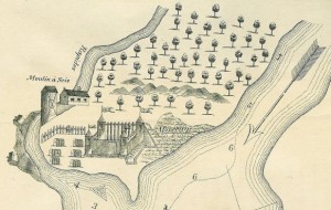
Figure 6.14 Fort de la Présentation was built by the Suplicians in 1749 as a mission to the Mohawks. By 1755 it had a population of 3,000 Haudenosaunee (Montreal had 4,000 people) and it was being repurposed for war.

Conflict in the Ohio Valley

Led by George Washington (1732-1799), a scion of the Virginian gentry and shareholder in a speculative land company, a Virginian party set out in 1753 to request that the French relinquish their position in the Ohio Valley. The result was intensified French activity in the region. The following year Washington returned (once again under orders from Virginia’s governor) and ambushed a French detachment. The French response (along with several of their Aboriginal allies) was to pursue and capture Washington at Fort Necessity before releasing him with a clear message for Virginia: the Ohio Valley was beyond their grasp.

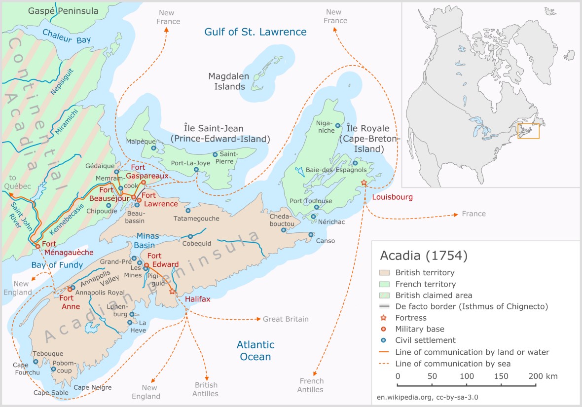
To this point in time, British conflict with the French had focused on the frontiers between New England and Acadia, New York, and Canada. The other British colonies had not been involved and there were occasions, such as during the War of the Austrian Succession, where New England struggled on its own without even the help of New York. British American population and economic growth by 1754, however, had reached a point where many of the largest colonies felt friction with New France. Georgia in the south was pinched between Florida and Louisiana; Virginia was both powerful and rich as well as increasingly cramped on the tidewater side of the Appalachians; New York’s ambitions for the west, along with those of Pennsylvania, pulled it into conflict in the Ohio; New England and Nova Scotia, as we have seen, continued to wrestle with Wabanaki Confederacy attacks and uncertainty about the Acadians and the future of Louisbourg. It was, perhaps ironically, the shared French threat that first brought together the disparate and disunified 13 British American colonies in an effort to work out solutions to common problems (and thus pave the way for further collaborations in 1775).

The French and Indian War

The American name for the Seven Years’ War  — the French and Indian War — reflects their perception that this was a battle against two old foes, and not merely one. Despite a massive imbalance in population numbers that favoured the British colonies (there were 20 British Americans for every resident of New France), the French colonies held their own. They did so principally by having better Aboriginal allies. The Council of the Three Fires — in particular, the Ottawa and the Potawatomi — were of special importance. The Haudenosaunee might have challenged French activity in the Ohio, but the British refused to support them against the expanding chain of French military/trading forts running from Lake Ontario to New Orleans.

Indeed, the Haudenosaunee were a powerful third force in the Ohio Valley. Since the Beaver Wars they had been extracting tribute from smaller client nations to the south, including the Shawnee and the Delaware. Recognizing that neither the French nor the British fully respected their interest in the region, they sought to whipsaw the Europeans against one another by means of a policy of “aggressive neutrality.”[footnote]Fred Anderson, Crucible of War: The Seven Years’ War and the Fate of Empire in British North America, 1754–1766 (London: Faber and Faber, 2000), 16.[/footnote] This strategy presented its own challenges, not least because Haudenosaunee control of the region was gradually shifting. Decades of human depopulation and warfare had allowed some of the local ecosystem to recover, making it highly desirable hunting grounds once again. Other Aboriginal peoples were, as a consequence, returning to the Haudenosaunee territories (to the chagrin of the Five Nations). These Aboriginal “colonists” in the Ohio were at odds with one another, as well as with the League and the British-Americans. Shawnee and Delaware resettlements in the Ohio were rubbing up against Miamis, Mascouten, and Kickapoos from west of the Great Lakes (they had shifted eastward to capitalize on trade with the British), and Wyandot (Wendat/Huron) remnants were huddled around the west end of Lake Erie. One scholar describes it as “a world of multiethnic villages outside of the French alliance and beyond the authority of the Iroquois Confederacy.”[footnote]Colin G. Calloway, One Vast Winter Count: The Native American West before Lewis and Clark (Lincoln: University of Nebraska Press, 2006), 331-2.[/footnote] There was, therefore, little Aboriginal solidarity and quite a lot of negotiable loyalties in relation to alliances with the Europeans, Canadiens, and Americans.

The Seven Years' War in North America.

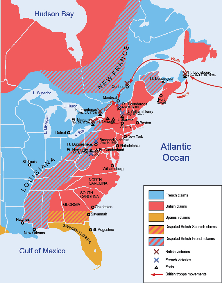
Figure 6.15 The Seven Years’ War in North America.

From 1754 to 1757 the war mostly tilted in favour of New France. For the first two years it was exclusively a colonial affair, but with the outbreak of war in Europe in 1756 new strategies emerged. The British, under Prime Minister William Pitt, believed they could tie up French armies in Europe and make use of their superior navy to harass the colonies of France abroad. France by contrast, under Louis XV, stuck to the tried-and-tested strategy of conceding little and banking on a good outcome at the treaty table. After all, return to the status quo ante bellum had worked well for France in one treaty after the next.

European War in North America

Nevertheless, France did commit regular troops to New France under the leadership of Louis-Joseph, the Marquis de Montcalm (1712-1759) in 1756. This was following a career marked by defeats and retreats in Europe. By that time the governor general of New France, the born-in-Canada Pierre de Rigaud de Vaudreuil de Cavagnial (1698-1778), had scored several important defensive victories against the British and the British Americans. In the Ohio and along the Great Lakes, Vaudreuil’s forces proved consistently more able than those of the British. The defeat of the British-American General Braddock in the Ohio in 1755 was a major coup for New France. Vaudreuil’s success stemmed from effective deployment of Aboriginal militias. Both Vaudreuil and Montcalm’s aide-de-camp, Louis Antoine de Bougainville, promoted the use of forest combat conducted by their Aboriginal allies and Canadien irregulars. As Bougainville explained, “In this sort of warfare it is necessary to adjust to their ways.”[footnote]Ibid., 340.[/footnote] The only offensive the British and their colonists were able to mount successfully was that against Fort Beauséjour, mentioned above.

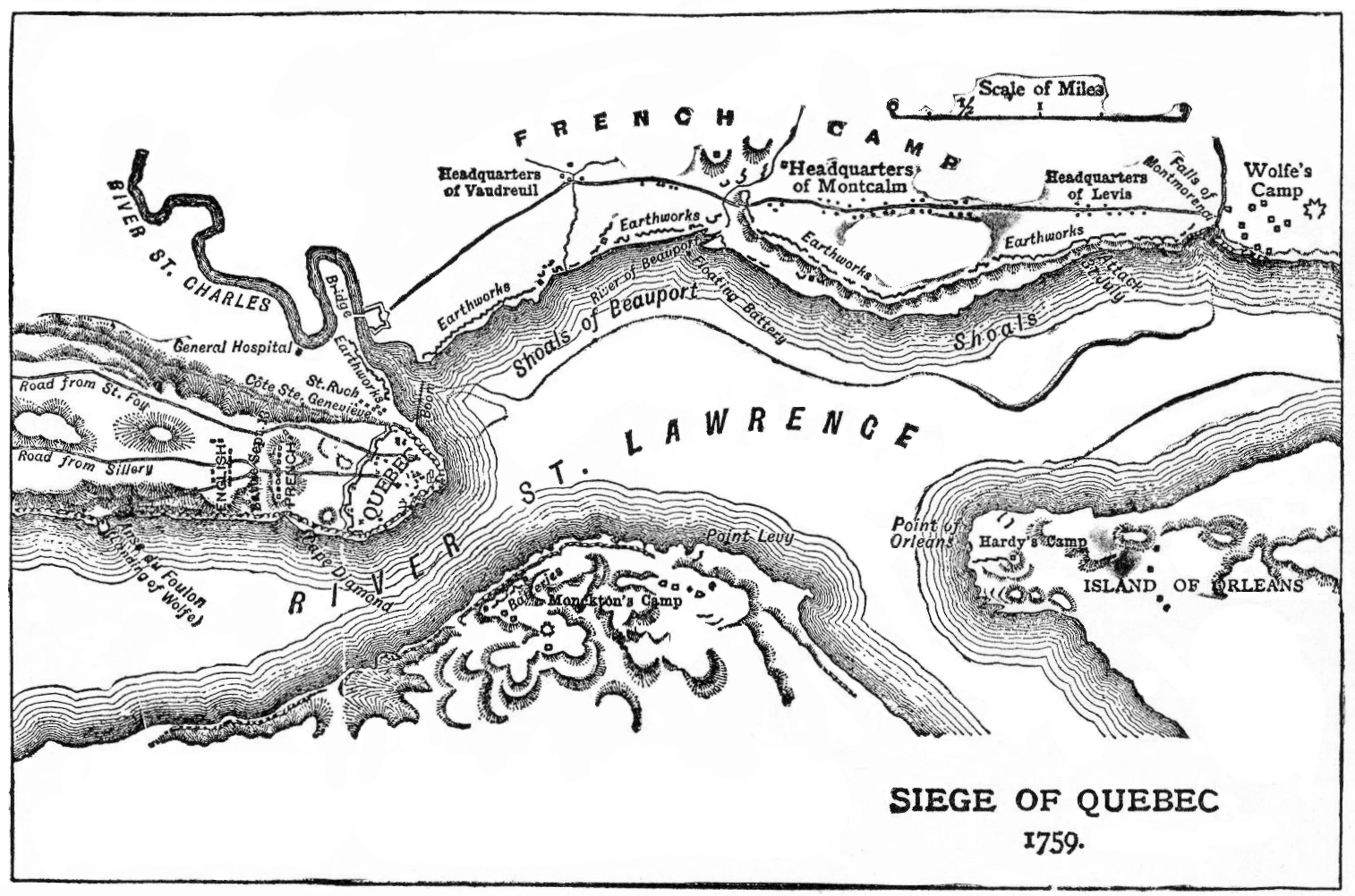
Figure 6.16 Fortress Quebec was, as this map shows, highly defendable, a tough nut to crack.

Montcalm’s arrival turned the colonial defence from a successful strategy of harrying the British with surgical strikes against their frontier to one of sit-and-wait. The new commander was more comfortable with set-piece battles, regarded Aboriginal warfare as uncivilized and unworthy, and demonstrated an unwillingness to press his foot down on an enemy’s throat. By 1758 he had lost the Ohio Valley which, in any event, he regarded as secondary to the importance of securing the St. Lawrence Valley. More than that, Montcalm went out of his way to undermine the reputations of his rival Vaudreuil and his friend, the intendant François Bigot. In 1758 Montcalm’s intrigues in the palaces of Paris paid out and he was promoted to lieutenant-governor and thus placed above Vaudreuil in the command of forces in Canada.

In 1759 the Royal Navy swept up the St. Lawrence and confronted Montcalm at the citadel of Quebec. Even in this instance, Montcalm’s instincts proved flawed. He thought (wrongly) that the river itself would confound the British, who were unfamiliar with its currents and hazards. He neglected to defend the height of land across the river from Quebec, which allowed the British to bombard the city into dust.[footnote]W. J. Eccles, “MONTCALM, LOUIS-JOSEPH DE, Marquis de MONTCALM,” in Dictionary of Canadian Biography, vol 3 (University of Toronto/Université Laval, 2003). Accessed January 12, 2015, http://www.biographi.ca/en/bio/montcalm_louis_joseph_de_3E.html .[/footnote]

The British forces, under the command of Major General James Wolfe (1727-1759), reached the Île d’Orléans in mid-June hoping for a quick victory. Although his army was smaller than he’d hoped, Wolfe nevertheless had some 7,000 troops and the support of nearly 200 vessels. Exploratory attacks on Canadien positions failed repeatedly, as had the relentless shelling of the Lower Town. By mid-September Wolfe’s troops were burning out the Canadien farmers, destroying their crops and thousands of homes in the hope of creating pressures on Quebec that might pay off  the following year. Many of his troops had deserted, morale was low, illness was depleting the ranks, freeze-up of the river was quickly approaching, and Wolfe himself was convinced that his mission was a failure. He was ready to abandon the attack and let the French and Canadiens struggle through a winter with limited food supplies, which he hoped would soften them up for a springtime assault.

"Après Guerre" shows the devastation of the Lower Town of Québec. It was painted by Richard Short, an officer in Wolfe's army who fought at the battle of the Plains of Abraham and Ste. Foy.

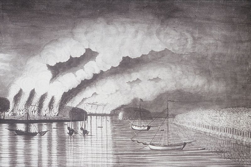
Figure 6.17 “Après Guerre” shows the devastation of the Lower Town of Quebec. It was painted by Richard Short, an officer in Wolfe’s army who fought at the battle of the Plains of Abraham and Ste. Foy.

The almost chance discovery of a landing point at a cove called L’Anse-au-Foulon was seized upon by Wolfe. On September 13, 1759, he assembled his troops on the Plains of Abraham. At this point, Montcalm had several options: wait for his reinforcements to arrive along Wolfe’s western flank and pin down the British; send out snipers along with Aboriginal and Canadien militiamen to gun-and-run until Wolfe’s troops were depleted and/or demoralized; stay in the citadel and wait out a British force that had little appetite or ability for a long siege in the face of oncoming winter (and just hope for the arrival of the French fleet); or march out onto the field and confront Wolfe. He chose the last of these.

The Blame Game

Louis du Pont Duchambon de Vergor was born in France in the year of the Treaty of Utrecht and joined the French military in 1730. The whole of his military career was spent in New France. His principal talents were skimming money out of the colonial purse, serving as “pimp” to the intendant François Bigot, privateering a bit on the side, and underperforming spectacularly in his military duties. Mme. Élizabeth Bégon de la Cour (1696-1755), a Montreal woman of considerable influence and even more wit, described Vergor as “the most dull-witted fellow I have ever met but he knows all the angles.”[footnote]Céline Dupré, “ROCBERT DE LA MORANDIÈRE, MARIE-ÉLISABETH,” in Dictionary of Canadian Biography, vol 3 (University of Toronto/Université Laval, 2003). Accessed December 13, 2014, http://www.biographi.ca/en/bio/rocbert_de_la_morandiere_marie_elisabeth_3E.html .[/footnote] This was, however, the man left in charge of Fort Beauséjour in 1754 and responsible for its fall to a British-New England force a year later. More than that, his actions played a role in precipitating the Acadian expulsion.

Low on credible troops, Vergor persuaded local Acadians to assist in the defence of the fort by promising that, if they were captured by the British, he would protect their official neutrality by claiming to have forced them into a compromised position. A two-week long siege, mutiny among the Acadians, and an exploding cannonball sealed Beauséjour’s fate: on June 16 Vergor ran up the white flag of surrender. The outcome for the Acadians who could not escape capture was exile, their participation in the battle taken by the British as confirmation that the Acadians were merely hiding behind a façade of neutrality. Vergor’s defence of Beauséjour was certainly anything but gifted. He was packed off to Canada where, in 1757, he walked away from a court martial thanks to his friend Bigot, who paid off the jury. For the next two years Vergor played a minor role in the defence of Canada, and the late summer of 1759 found him in charge of a sentry post at the Anse au Foulon. It was there, in the early hours of September 13, that Wolfe’s forces found a path from the river to the Plains of Abraham, surprised the inattentive Vergor and his men, and assembled for the battle with Montcalm. Having lost Acadia, Vergor might be blamed for the fall of Canada as well.[footnote]Bernard Pothier, “DU PONT DUCHAMBON DE VERGOR, LOUIS,” in Dictionary of Canadian Biography, vol. 4 (University of Toronto/Université Laval, 2003). Accessed December 13, 2014, http://www.biographi.ca/en/bio/du_pont_duchambon_de_vergor_louis_4E.html . [/footnote]

Victory, it must be added, was by no means guaranteed to the British troops that day. Wolfe seized on the worst position he could have selected and stayed there, despite better options. Montcalm’s insistence on attacking in columns rather than in lines, on using regular troops and set-piece tactics rather than letting loose Vaudreuil’s shock troops, cost the French dearly. It is a pivotal moment in the history of Canada, and yet it unfolds so badly that its two principal actors — Wolfe and Montcalm — were both killed or mortally wounded in battle, something that rarely happened in European warfare. Considering the Battle of the Plains of Abraham, historian William Eccles wrote many years ago that “perhaps the most overlooked determining factor in history has been stupidity.”[footnote]W.J.Eccles, “The Battle of Quebec: A Reappraissal,” Essays on New France (Oxford: OUP, 1987), 133.[/footnote]

From Defeat to Conquest

To be sure, the war was far from over in September 1759. The bulk of the French troops retreated to Montreal where they licked their wounds. The Chevalier de Lévis, Montcalm’s successor, had 7,000 troops with him in April 1760 when he confronted a much smaller and rather sickly British army at the Battle of Sainte-Foy. The French won easily but they could not retake Quebec, and the hoped-for French fleet failed to arrive (having been sent to the bottom of the sea by the Royal Navy at Quiberon Bay). Instead, British ships reached Quebec when the river ice melted and in September, one year after the Battle of the Plains of Abraham, Montreal fell.

A great deal has been written about this battle because it represents for many a turning point in the history of Canada. It is the moment at which Canada fell to the British; it is the moment of “the Conquest.” Of course it was not: that happened at the treaty table four years later. What Wolfe accomplished on the Plains of Abraham might well have been undone at the Treaty of Paris. Britain decided that, strategically, Canada was a better choice than one of its other prizes: the sugar colony of Guadeloupe. Keeping Canada would put an end to the hemorrhaging expense of continuous colonial war in North America. This would, of course, entail maintaining a northern colony populated by hostiles, so it was not entirely positive from the perspective of Britain. France, for its part, agreed with the decision. Canada would be hard for Britain to hold and the removal of French influence from the Ohio would be like unstopping a drain: the American colonists would become difficult to contain. Being allowed to keep the lucrative West Indian island must have seemed to the French negotiators like the best possible outcome. Besides, Quebec had fallen before in colonial struggles, and it had always been restored, a possibility that could be held out to the Canadiens and those business interests in La Rochelle and Breton whose livelihoods were closely tied to that of the colony. In other words, France had not entirely given up on Canada, nor had Canada given up entirely on France.[footnote]Helen Dewar, “Canada or Guadeloupe?: French and British Perceptions of Empire, 1760-1763,” Canadian Historical Review 91, no.4 (2010): 637-60.[/footnote] As for the British, winning New France was one thing, but holding it was another.

Map of Montréal in 1749. The fortifications can be seen as can the gardens of the seminary and the Hôtel-Dieu. (Source: Library and Archives of Canada.)

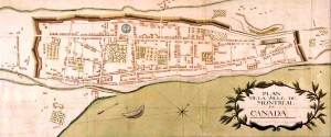
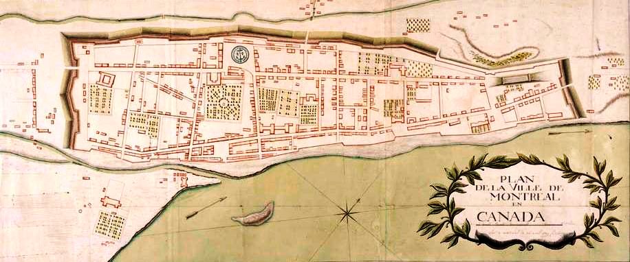
Figure 6.18 Map of Montreal in 1749. The fortifications can be seen as can the gardens of the seminary and the Hôtel-Dieu.

The Legacy of the Seven Years’ War

First, New France was at an end. The British claimed everything north of Florida. France gave Louisiana west of the Mississippi River to its ally Spain in compensation for Spain’s loss to Britain of Florida (which Spain had handed to Britain in exchange for the return of Havana, Cuba). France held on to western Louisiana until 1803, but otherwise its colonial presence north of the Caribbean was reduced to the tiny islands of Saint Pierre and Miquelon. Britain’s position as the dominant colonial power in the eastern half of North America was confirmed.

The outcome of the Seven Years' War looked like a commanding future for Britain in North America. Everything from tidewater to the Mississippi, the Gulf to the Arctic was British.

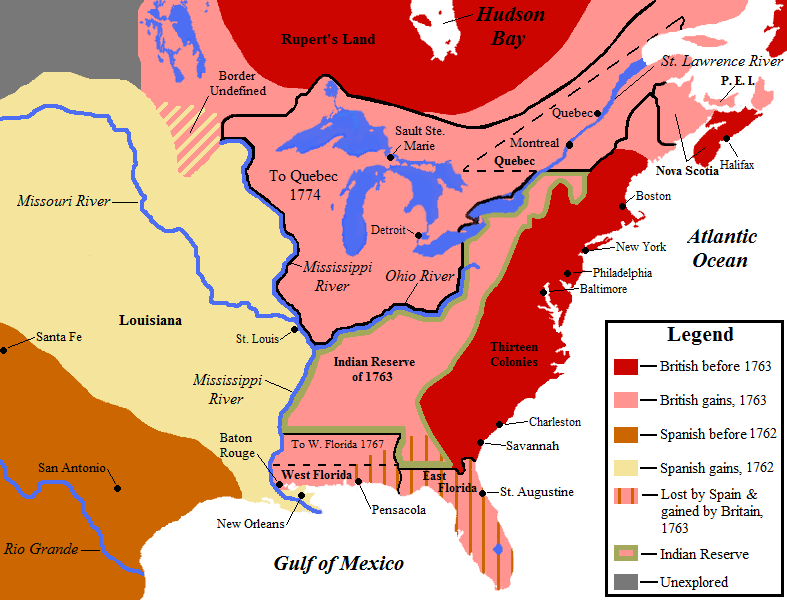
Figure 6.19 The outcome of the Seven Years’ War looked like a commanding future for Britain in North America. Everything from tidewater to the Mississippi, the Gulf to the Arctic, was British.

Second, French absolutism was in trouble. The war in Europe had been expensive and the country was impoverished as a result. Many factors contributed to the French Revolution in 1789, and the Seven Years’ War was one of them. This situation curtailed any hope of a restoration of French power in North America. It also led to further global conflicts and, more importantly, to the rise of secular and democratic modern society — not just in France but all around Western Europe and across the Atlantic.

Third, the outcome boded ill for Aboriginal peoples. For many of the nations, the elimination of French power in North America meant the disappearance of a strong counterweight to British expansion. Most obviously the Haudenosaunee strategy of whipsawing the two European powers against one another was eliminated. Pressures increased on Native populations from the Atlantic seaboard through the Ohio and Mississippi, producing waves of refugees as one population after the next was dispossessed. These westward-moving exiles, in turn, pushed other Aboriginal peoples along as well. Tensions built swiftly and produced further conflict.

Fourth, the British American colonies felt entitled to the spoils of war. The Ohio Valley lay ahead of them, unopposed by French forts (regardless of Aboriginal resistance). More to the point, the British regime was not certain that it was ready to unleash colonial America from behind the Appalachian barrier. The farther the colonies spread, the more likely it was that Britain would be called on to defend them against Aboriginal attacks. The cost of the Seven Years’ War was high enough and Britain’s treasury needed time to recover. As well, Britain feared that an open frontier would only make the Americans more difficult to govern.

Finally, the war had provided an opportunity for militiamen from New England through Virginia to cut their teeth on battle. George Washington, for one, had gone from a brash and inexperienced soldier at age 22 to a far more confident and mature military leader, thanks to the opportunities provided him by service to Britain. The Seven Years’ War was the first occasion in which the Thirteen Colonies had pursued common goals, and it gave a boost to their ambitions.

For Acadia and Canada the end of the war brought uncertainty and fear. Acadian society was shattered by the Expulsion. Its outposts on the western mainland of Northumberland Strait and in the new British colony of Prince Edward Island struggled to survive under the new administration. No doubt more than a few hoped for another exchange of imperial masters, but that wheel had stopped turning. The Canadiens, for their part, continued to hope for relief from France while watching nervously the deportation of the Acadians.

The “land hunger” that had propelled British Americans into the Ohio and into wars against the Wabanaki Confederacy was to have very direct consequences for Nova Scotia and Canada. Some of these would be felt immediately as migrants poured (in smallish numbers) into both colonies. The trickle, however, would become a torrent in less than a generation.

Key Points

  • The first intercolonial conflicts associated with the Seven Years’ War took place in the Ohio Valley and were instigated by Virginian expansionism into French/Aboriginal territory.
  • The involvement of Virginia presaged a war between New France and the whole of the British colonies, rather than just New England, Nova Scotia, or New York.
  • British success was predicated mainly on a vastly larger colonial population and a significant commitment of military resources.
  • The Conquest of Canada occured at the negotiating table.
  • The outcome of the Seven Years’ War had almost immediate implications for relations between Britain and its original colonies and for the French absolutist regime. It also boded ill for Aboriginal peoples in the Ohio Valley and beyond.

Attributions

Figure 6.14
Fort de La Présentation by Charny is used under a CC-BY 3.0 license.

Figure 6.15
French and Indian War by Hoodinski is used under a CC-BY-SA 3.0 license.

Figure 6.16
Fortress Québec by Tango22 is in the public domain.

Figure 6.17
Après guerre by Jeangagnon is in the public domain.

Figure 6.18
Map of Montreal 1749 by Jeangagnon is in the public domain.

Figure 6.19
NorthAmerica1762-83 by Creysmon07 is used under a CC-BY-SA 3.0 license.

Posted in Uncategorized | Leave a comment

4.9 War in the Pays d’en Haut

The French enjoyed the support of most of the Aboriginal nations in the Ohio, Great Lakes, Mississippi, and Illinois territories for several reasons. They did not demand concessions of land, they arrived as (and generally behaved as) guests, they regularly and systematically gave gifts of various kinds to maintain alliances, and they engaged in a fur trade that was lucrative for most of the Aboriginal participants. However, the French record in the Pays d’en Haut was not unblemished.

Detail from a map of the Pays d'en Haut in 1718. The Meskwaki and their allies, the Mascouten and the Kickapoo controlled much of the rivers systems to the south and west of Lake Michigan. Created by Guillaume Delisle.

Figure 4.19 Detail from a map of the Pays d’en Haut in 1718. The Meskwaki and their allies, the Mascouten and the Kickapoo controlled much of the rivers system to the south and west of Lake Michigan.

The Fox Wars

From about 1700 the French were at odds with the Meskwaki (a.k.a. Fox) who controlled the river corridor that connects Lake Michigan to the upper Mississippi valley. The Meskwaki sought to hold their position as intermediaries in trade between the Council of Three Fires (the Potawatomi, Ottawa, and Anishinaabe/Ojibwa) and their French partners and the Sioux nations to the west. The Meskwaki had little reason to love the French; it is likely that the Wendat — armed by the French — displaced them from southern Ontario in the early 17th century. The French, for their part, wanted unfettered access to the Sioux and the Plains. The Meskwaki held certain advantages at the beginning of the conflict but the tide quickly turned badly against them.

Two major conflicts erupted between the French and their allies and the Meskwaki in the 18th century in what became known as the “Fox Wars.” The first occurred in 1701 at Fort Pontchartrain (Detroit), after which a lively traffic in Meskwaki slaves opened between Green Bay and New France. War picked up again in 1712 and was more or less continuous into the late 1720s, at which point it became a genocidal campaign with even the smallest numbers of refugees from devastating battles being hunted down and executed. From 1728 to 1732 the governor of New France, Beauharnois, punished the Meskwaki. The governor’s biographer attests that he

encouraged post commanders, western allies, and mission Indians to fall upon the remaining Foxes at every opportunity, until “that damned nation shall be entirely extinguished.” In 1733 the principal Fox chief, Kiala, begged for mercy. Beauharnois sent him to Martinique in slavery. If the remaining Foxes would not be dispersed among the missions within the colony, they were to be killed. [footnote]S. Dale Standen, “BEAUHARNOIS DE LA BOISCHE, CHARLES DE, Marquis de BEAUHARNOIS,” in Dictionary of Canadian Biography 3 (University of Toronto/Université Laval, 2003). Access October 20, 2014, http://www.biographi.ca/en/bio/beauharnois_de_la_boische_charles_de_3E.html.[/footnote]

Only a few hundred Meskwaki survived the Fox Wars.

It is important to note that, whatever Beauharnois might have wanted, it could not come to pass without the support of the Aboriginal allies. What this grim campaign in the Pays d’en Haut reveals is complex. First, it puts the lie to the myth of unqualified positive relations between the French and their Aboriginal neighbours. The French may not have been interested in annexing lands but they were as driven by greed and pride as any other peoples. Second, the Fox Wars were a test of the strength of French diplomacy among their allies. A test that the French passed utterly. Third, and to build on that last point, the influence of European goods, commerce, and military alliances was having far-flung impacts across the middle of North America, and not only in Canada, Acadia, or the Mississippi Delta. Generally the position of the French was strong. The same could not be said of the Virginian colonists who at this time decided to explore the possibility of expanding across the Appalachian Mountains and into the Ohio Valley.

Key Points

  • The Pays d’en Haut was a critical bridge between the two larger French settlement colonies.
  • The Fox Wars constituted a test of the ability of the French to secure their goals among Aboriginal communities.
  • The French were, with the support of their allies, able to inflict significant losses on enemies located thousands of kilometres away from Canada and Louisiana.

Attributions

Figure 4.19
Michigan 1718 by Jeangagnon is in the public domain.

Posted in Uncategorized | Leave a comment

6.10 Acadia 1713-1755

Île St.-Jean (aka Prince Edward Island) in the 1740s was a significant piece of the Acadian farming and sea-going frontier.

Figure 6.9 Île Saint-Jean (a.k.a. Prince Edward Island) in the 1740s was a significant piece of the Acadian farming and seagoing frontier.

Historians think of Acadia as a society as much as a place. After 1713, the French possessions in the region were both reduced and augmented. Île Saint-Jean and Île Royale were some distance from the Bay of Fundy where most of the Acadian settlements were located. Those were now under the nominal control of the British. The two islands held a rump population of Acadians but, soon after Utrecht, the French erected the largest of their colonial outposts on Royale: Fortress Louisbourg. Built in 1720, Louisbourg soon became the busiest of the French ports in North America and rivalled most of the British ports to the south in terms of volume of trade. Clearly it had both military and commercial functions. It also served as the administrative headquarters for the two colonies in the Gulf of St. Lawrence.

Louisbourg played a role, too, in sustaining the Acadian communities then behind enemy lines in Nova Scotia. At first the French sought to entice Acadians from the Bay of Fundy to resettle on Île Royale. The soil around Louisbourg, however, was too miserly so the Acadians opted to stay put. This pleased the British insofar as Acadian farms contributed positively to Nova Scotia’s bottom line, but the question of Acadian loyalty was to dog both sides for decades. The British were certain that Louisbourg was a disruptive factor in the internal affairs of Nova Scotia; the Acadians were exasperated by years of war and oscillations between British and French overlords, on the one hand, and enemy pirates and raiders on the other. The French, for their part, wanted some time to rebuild their position without being drawn too far into the affairs of the Acadians and the Wabanaki Confederacy.

Fortress Louisbourg, ca. 1752.

Figure 6.10 Fortress Louisbourg, ca. 1752.

Repeated efforts were made on the part of the British to secure an oath of loyalty from the Acadians. France, of course, did not want this but, more importantly, neither did the Wabanaki Confederacy. Pro-British Acadians, the Wabanaki concluded, would be by definition hostile to the Confederacy. Indeed, the French spurred on Wabanaki attacks on the British throughout the 18th century, using the Confederacy as the means to harass their enemy.

The Third Wabanaki War

The Wabanaki did not need much encouragement. Immediately after Utrecht they complained of British and New Englander incursions into their territory and pointed out that, regardless of what France signed away, they did not agree to any division of their lands with the Europeans. This was definitely true of the Mi’kmaq and probably the Abenaki (Malecite) as well. The New Englanders understood the situation differently and repeatedly edged into Wabanaki territory, establishing settlements and sometimes forts. This occurred over a broad geography, from Vermont to Île Royale, and the Wabanaki response was, likewise, wide-ranging. The Third Wabanaki War (also known as Father Rale’s War) entailed serious frontier squirmishes, naval battles, assaults on fortified positions, and guerrilla attacks designed to terrorize one another. From 1722 to 1725 the Confederacy launched raid after raid on British settlements in New Hampshire, Vermont, Maine, and Nova Scotia. They targeted individual towns and farmhouses in an attempt to drive the New Englanders back to their pre-1713 positions and the British from their newly claimed lands. The New Englanders retaliated and the British established Fort Canso, a fishing post and defensive position across Chedabucto Bay from Île Royale, in a territory that was unambiguously claimed by the Mi’kmaq.

For the most part these hostilities — although almost continuously running and bitterly fought — were inconclusive. However, in the western theatre of war the Confederacy and New England came to an agreement called Dummer’s Treaty (1727), named for the Governor of Massachusetts. The terms were not favourable for the Confederacy but they established the principle that the Wabanaki were legitimate inhabitants of the region now described as New Brunswick and that they would have to be consulted in future diplomatic agreements.

Acadia’s “Golden Age”

Despite the conflict in Maine and eastern Nova Scotia, life in the Bay of Fundy was largely peaceful for the core Acadian settlements. Their system of governance was like that of the English colonies although with a slight seigneurial twist. A century of benign neglect by France had come with a cost in terms of security and vulnerability but there were freedoms arising from that as well. Local councils provided a largely informal administrative system, one that (after Utrecht) sent representation to the British headquarters at Annapolis. The British showed official tolerance for Catholicism, although the colony was not especially well supplied with clergy. What churchmen there were provided a level of leadership but not authority, another distinction from what existed in nearby Canada under the royal administration.

The period from 1713 to 1748 has been described by historian Naomi Griffiths as a “golden age,” one in which family sizes grew and average life expectancies improved and were better than in France, Canada, or New England. Direct involvement in war was very limited, epidemics ignored the growing Acadian settlements, and commerce with New England was conducted in a largely effective and mutually beneficial way. Illicit trade with Louisbourg also thrived as Acadians shipped boatloads of surplus livestock to the French bastion.[footnote]Naomi Griffiths, “The Golden Age: Acadian Life, 1713-1748,” Histoire Sociale/Social History 17, 33 (May 1984): 21-34.[/footnote]

Some of these quality-of-life indicators can be measured and verified but, against that trend, this was also an era of significant Acadian and Mi’kmaq migration out of the Fundy Basin and onto Île Saint-Jean by the 1750s.  As well, the putative peacefulness of the region was regularly jeopardized by British imperial designs and Mi’kmaq resistance. The existence throughout this period of an Acadian militia also indicated that things were not all well among the people known to the British as “the neutral French.”

The story of Acadia from 1713 to the 1750s sometimes references the benefits of isolationism. By staying out of the way of wars, minimizing contact with their neighbours, and growing rapidly from internal sources, the Acadians were able to avoid combat deaths, epidemics, and internal division. This is not supported by evidence of extensive external trade and considerable immigration: a third of the individuals involved in 174 marriages at Grand-Pré in the 18th century came from France, Île Royale, and even Canada. Whatever caveats might be added to the story of a “golden age,” Griffiths is right that the key to understanding the more positive aspects of this community memory is that it sustained the Acadians in what was to come after 1748.

Nova Scotia, Acadia, Wabanaki

European war from 1740-48 (the War of the Austrian Succession) provided the French with an excuse to attack Nova Scotia from Louisbourg. In reply, New Englanders mounted an assault on the fortress and found its defences to be easily penetrated. Louisbourg was captured in June 1745 and, for the next three years, the British and New Englanders controlled the whole of the North American foreshore from Georgia to Newfoundland. They took advantage of this situation to clear Île Royale of several thousand francophones, including many Acadians. This was a grim foretaste of things to come.

The New Englanders’ capture of Fortress Louisbourg was not a victory they were able to enjoy very long. The 1748 Treaty of Aix-la-Chapelle (which restored the status quo ante bellum) had several immediate consequences for the Acadians and the Mi’kmaq. The first of these was pressure from the French to take their side, an offer the Acadians declined. Knowledge that their Acadian subjects might yet jump to the enemy, however, placed the British in a dilemma. The prospect of an end to Acadian neutrality and the certainty of renewed Mi’kmaq hostilities prompted the British to establish new positions in Mi’kmaq territory. The foremost of these was Halifax, placed squarely where the British had earlier promised the Mi’kmaq they would not go: at Jipugtug (Chebucto). Its establishment in 1749 and the arrival of more than 2,000 settlers resulted in another conflict that came to be known as the Mi’kmaq War or Father Le Loutre’s War.

An orderly representation of early Halifax, 1750, complete with stocks and gallows by the waterfront.

Figure 6.11 An orderly representation of early Halifax, 1750, complete with stocks and gallows by the waterfront.

Halifax was established under the governorship of Edward Cornwallis (1713-1776), a 36-year-old British aristocrat who started his term hopeful that peace could be established with the Wabanaki Confederacy. Initially it looked as though his goals would be realized: he had a good-sized core of British settlers, Royal Navy support, and a signed agreement with the Wabanaki. Sadly, the Mi’kmaq were not part of the treaty process. They responded with a letter that made clear their position: “The place where you are, where you are building dwellings, where you are now building a fort, where you want, as it were, to enthrone yourself, this land of which you want to make yourself absolute master, this land belongs to me.”[footnote]Quoted and translated in L.F.S. Upton, Micmacs and Colonists: Indian-White Relations in the Maritimes, 1713-1867 (Vancouver: UBC Press, 1977), 201.[/footnote] Mi’kmaq attacks followed soon after.

Cornwallis’s response was to stand his ground and, indeed, to expand the British military presence in the region. New forts and barracks went up at Windsor, Dartmouth, Grand Pré, Bedford, Mirligueche (Lunenburg), and Chignecto (Fort Lawrence). Much of this construction was in and around the Minas Basin, part of the Acadian heartland. The disputed territory to the north (the area that later became New Brunswick) bristled with French forts in response. Cornwallis’s gestures may have been large but his effectiveness was questionable. In 1749 he announced a bounty on Mi’kmaq scalps. This was a practice common in New England for a century or more and the French were already offering the Mi’kmaq a bounty on British scalps. The bounty was wholly ineffective and failed to mobilize a strong response to the Aboriginal militias.

Acadia and Nova Scotia, 1754

Figure 6.12 Acadia and Nova Scotia, 1754.

Father Jean-Louis Le Loutre was a Catholic priest deeply involved in the Wabanaki resistance and, when it came to English scalps, the paymaster of the French as well. In the late 1740s he organized an Acadian exodus to Île Saint-Jean. Reducing the number of Acadians in Nova Scotia was a means of weakening British food supplies, but the French/Acadians/Wabanaki were able to keep open and protect a land corridor that ran across the disputed territories, the Chignecto Isthmus, making travel from Canada to Louisbourg possible.

Under the circumstances, Cornwallis could not gain any ground, nor could he subdue his opponents. He left the colony and the war dragged on inconclusively until 1755. The legacy of his term, however, is important: no comparably sized region in the history of British North America was ever so militarized, no conflict so intractable, and never was so much potential goodwill lost. What looks on the face of it like an Acadian victory was in fact a disaster, one that unfolded in different ways. The Acadians who relocated to Île Saint-Jean were beset in 1749 by a plague of black mice that destroyed their crops. This was followed by another plague in 1750, this time of locusts. In 1751 drought struck. And, of course, the British were becoming increasingly exasperated with the Acadians. Hundreds if not thousands had abandoned neutrality and sworn loyalty to France. Indeed, many of the British settlers brought in by Cornwallis and his successor — some of whom were actually German and French Protestants — deserted the British and joined the Acadians and the French.

Oaths and Exile

The new governor of Nova Scotia, Charles Lawrence (1709-1760), decided to push the issue of an Acadian oath of loyalty. The Acadians who remained in the Minas Basin and generally on the north shore of Nova Scotia were still reluctant. International circumstances had changed, however. War had broken out in the Ohio Valley in 1754 and Europe was edging toward another precipice of its own. A joint British-New England operation captured Fort Beauséjour. The Wabanaki raids, too, continued. Further Acadian refusal to take the oath in 1755 prompted Lawrence, with the support of Governor William Shirley of Massachusetts, to begin relocating Acadians to the British colonies to the south, to France, to Louisiana (where they adapted to bayou life as Cajuns), to wherever they could be sent.[footnote]The complex context of the expulsion is considered in Naomi Griffiths, From Migrant to Acadian: A North American Border People, 1604-1755 (Montréal & Kingston: McGill-Queen’s University Press, 2005), 431-64.[/footnote]  The British forces set ablaze the emptied Acadian villages and then repopulated them with British American colonists called planters and by new immigrants from Yorkshire. The Acadian Expulsion (in French, Le Grand Dérangement) did not occur overnight. This was an eight-year long episode, during which time some Acadians returned, a great many perished, one group hijacked their captors’ ship and sailed to Canada, and those on Île Saint-Jean thought, mice and locusts notwithstanding, they had made a smart move.

"A View of the Plundering and Burning of the City of Grymross" was painted in 1758 and is thought to be the only contemporaneous  study of the Acadian deportation. One gets a sense of the "scorched earth" policy at work, although the scalpings are not depicted here. (Grimross is now Gagetown, New Brunswick.)

Figure 6.13 “A View of the Plundering and Burning of the City of Grymross” was painted in 1758 and is thought to be the only contemporaneous study of the Acadian deportation. One gets a sense of the “scorched earth” policy at work, although the scalpings are not depicted here. (Grimross is now Gagetown, New Brunswick.)

Key Points

  • The Treaty of Utrecht (1713) redefined the boundaries of Acadia in such a way as to worsen tensions between the French, the British, the Wabanaki Confederacy, and the Acadians.
  • The Acadian response to repeated turnovers in imperial masters and ongoing tensions was to seek a position as the “neutral French.”
  • Acadian communities enjoyed significant growth in this period, marked by natural population growth and increased farm productivity.
  • Renewed struggles between the French and the British and between the British and the Mi’kmaq at mid-century resulted in a more militarized region and, ultimately, the Acadian Expulsion.

Attributions

Figure 6.9
Acadie1744 IPE by Jeangagnon  is in the public domain.

Figure 6.10
Plan de Louisbourg vers 1751 by AYE R is in the public domain.

Figure 6.11
StocksHalifaxNovaScotia1750 by WarBaCoN is in the public domain.

Figure 6.12<
Acadie 1743 nl by Mikmaq is used under a CC-BY-SA 3.0 license.

Figure 6.13
A View of the Plundering and Burning of the City of Grymross by Hantsheroes is in the public domain.

Posted in Uncategorized | Leave a comment